
Hey all, as promised earlier in the summer I would you guys a forecast for the upcoming summer, more specifically the tropical region. Being that I'm waiting for my plots to get looked over at the office right now, I figured its as good of a time as any to write this bad boy up.. Plus its a pretty interesting day in the Mid-Atlantic weather wise as I'm sure a lot of you have noticed
So lets get started! As I'm sure you've all heard last year was a..... uh.... godzilla el nino

UVA needs to hire this guy to Photoshop in some empty stadium seats
first off, it might be a good idea to really get into what El Nino is, and what it does globally seeing as that is not common knowledge. El Nino (if you wanna get picky...El Nino Southern Oscillation) is an influx of warm water off the coast of South America. Normally, a pressure difference across the Pacific drives winds that push this warm water westward towards Australia, bringing with it rain and monsoons. However for whatever reason (still not totally understood by scientists) this gradient weakens thus weakening the winds, or even changing their direction from east to west, to west to east, which ultimately results in a buildup of this warm water off the coast of South America. Now the debate for what causes El Nino is a bit of a chicken and the egg debate, we know that both the pressure and the winds have effects on one another, but we're not entirely sure which one becomes weakened first and why...just that it happens
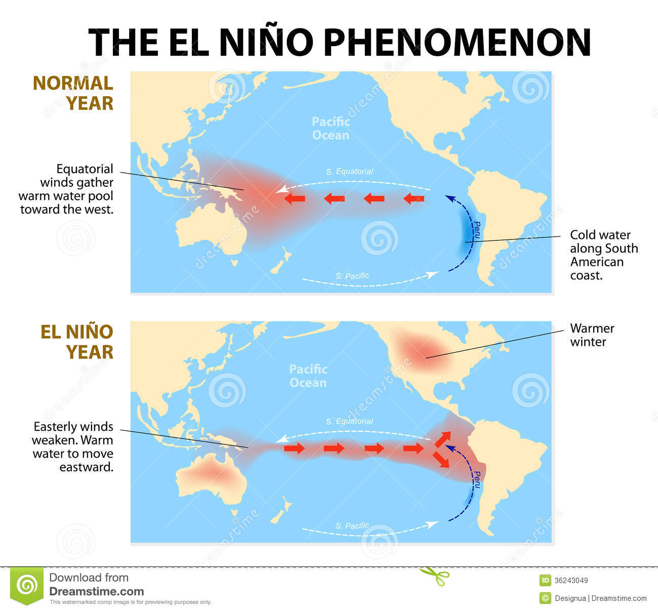
pretty good indicator of what happens
So, go figure, the oceans and the atmosphere are tied together pretty well. The ocean circulation drives a lot of what happens with global climate and circulation systems, which means if you have a giant wrench thrown into the system its probably going to royally screw some things up. So when El Nino occurs theres a lot of regional and international effects that can cause both drought in regions that are used to rain seasons and floods in places that are used to drier seasons.

this pretty much sums up the effects
I'll go into a brief synopsis of why each region experiences the effects they do
Australia and surrounding region - Less rainfall, as mentioned before the change in wind direction results in a blocking high pressure system forming over the region. This gives them much less rainfall than usual and as a result the area experiences drought. As a result the continent and surrounding islands experience spikes in forest fires
Africa - Eastern Africa experiences significantly increased rainfall. This most recent El Nino for instance, which lasted for three years, was met with happiness at first. Rainfall produced greater crop yields in the first growing season. However as the El Nino event increased in strength and prolongued, the region experienced heavy floods which destroyed crops ultimately resulting in famine and increased outbreak of disease. Western, Central, and Southern Africa all experienced above average temperatures and less rainfall than usual during the last El Nino event resulting in famine in those regions as well.
Asia - As warmer waters shift westward, rainfall goes with it. Regions that typically rely on monsoon season to provide rainfall for their crop yields suffer from massive drought and as a result loss of food and fire are frequented in the region. Famine broke out in this most recent El Nino in regions of southeast Asia and India. Crop yields were well below normal
North America - In North America, due to our increased resources in studying it we believe we have a general idea on regional effects. In Canada and most of the northern US (minus the northeast) winters are typically much more mild and warmer. I can personally vouch for this seeing as the winter this last year got below 0 for an entire day only 4 separate times in Wisconsin (really low amount) and the lakes had thawed out by late march (which was really early). In the Sourthern States things are typically a little bit cooler, with an increased rainfall, although there are fewer hurricanes (I'll get into that in another discussion). The Pacific northwest experiences drier conditions. Last but not least is the Pacific Southwest, which I'm calling BS on this chart on. Studies have indicated that there is little to no connection there with rainfall amounts, and if anything rainfall decreases or maintains its usual rate during El Nino events....so yeah, take that wikipedia
South America - Basically south America receives more rainfall and becomes more seasonal as a result of the warm water pool right off coast. The entire continent gets cooked up and becomes a little bit hotter as well during these events. Typically warmer waters favor mosquito development and thus increase the spread of viruses, so expect to see some papers come out the next few years about GODZILLA EL NINO's effects on the spread of the zika virus.
So yeah, all and all, El Nino is some pretty crappy stuff. But I have good news!

kinda wanted to fit professor farnsworth in there
We're transitioning out of an El Nino, and into El Nino's sister, the aptly named La Nina (La Nina literally translates to the girl, and El Nino the boy). We're not quite sure yet how severe this La Nina event is going to be, so I cant make any predictions there. However it could be fun coming up with a few names if it is another historic event. Is there a female godzilla? would they call it a godzilla La Nina, or would they come up with something else ridiculous? Either way, this spells some interesting upcoming years for the southern states. As I briefly stated earlier hurricanes are less frequent during El Nino years, which if people express enough interest I'd be more than happy to do a really extensive write-up on the why. If you haven't picked up on it yet La Nina is the exact opposite of El Nino.

seriously, take a careful look at this image and compare it to the el nino one from above

ITS THE EXACT OPPOSITE. This is because La Nina is an increase of the low over Australia, resulting in more warm water moving and staying in the western Pacific. more rain in Asia, less rain in the southern states, more rain in Australia and Pacific Northwest etc. Also expect increased hurricane activity depending on the severity of the event. So you literally just take everything I wrote previously and flip it. High pressure to low pressure, hot to cold, dry to wet...etc you get the point
What this means for this summer
Basically look at this summer as a transition year so it should be pretty moderate. We'll probably see an increase in the number of hurricanes relative to the last few years, but lets be real the last few years have been pretty slow. The next year is the summer you want to watch out for. La Nina will probably be bigger than usual (although maybe not godzilla big...maybe like hydra big) bringing in a lot more hurricane activity and rainfall in our typical vacation areas down south.

#hydraLaNina
hope this helped you guys understand some weather phenomena and some of the global impacts of El Nino a little bit. If you have any questions about anything letme know. Again if you guys are interested I'll be more than happy to cover my that I did last night on La Nina/El Nino's effects on regional hurricane genesis and development. It'll get into a lot of details about hurricane formation too
GO HOKIES!


Comments
As a native Californian, most of our weather seems to come from El Nino years. For example, this was the first time in about 3 years that it actually rained while I was home for Thanksgiving or Christmas. People get pretty worked up about it, probably because it's the only time anything, y'know, happens there.
As long as hurricane season brings some good surf, it's all good. And it would be nice for it to show up early for a good ECSC
Living in the Outer Banks....i definitely agree with you, as long as hurricane season doesn't bring much damage (for me personally, and because of the duties of my job if it does happen)
Oh yeah where in the outer banks do you live
KDH, near MP 7
How's the weather looking for the 4th weekend? Will be coming down from Michigan.
Little far out for the models to be zeroed in. Id be more than happy to give a forecast in about a week
Accuweather says mid 80s and sunny, few scattered t-storms...if you trust accuweather
those tstorms are worrying me but with it being the beach i find the forecast can change so fast.
Its still a good ways out
This is a really great refresher of everything I pretty much already knew. Thanks Esh!
/s
Anyone have the Chris Farley gif?
For those of you who don't speaka espanol, EL Nino means "The.........Nino."
BOOM...knowledge
So in other words, El Nino, Godzilla, Maps, Good News, Dragons, Hokie. Aren't there emoticons for this?
Depends if you like hurricanes. Good news is this should be a pretty moderate year. If youre in florida, and things work out like we think they might, next year could be brutal
A full blown well done on this- it was a great primer for the understanding how these worldwide weather patterns work.
Moving a bit north- I'm trying to figure out my homeowner's insurance deductibles. What do you see for hurricane activity in the Savannah GA/ Hilton Head area this year and next- More or less activity than normal?
Savannah georgia is far enough north that most hurricanes will lose a lot of their muster by the time they strike. However id expect to start seeing an increase in hurricanes in the region these next couple of years for sure
So El Nina means Ohio is gon' be wet!? That means I can go ahead and seed the yard in summer this year?
Again maybe not this summer, but the next should be wetter than usual
Awesome report, one that I will refer to repeatedly - and not a single mind numbing, computer clogging, pop up or click bait!
Thanks, so much. I spend quite a bit of time following the weather, and meteorology in general. I actually prefer my own "forecast" over the news, given all the resources now available on line. I'm into it, especially now living in the Keys. Living on the water, as I have since the 90's, gives you quite the incentive.
I do have a question. I saw a graphic on TV last year, that implied correlating hurricane activity/probability on a certain convergence of 2 separate atmospheric levels, spinning around the tropics at different speeds. I only saw this briefly, and I think it was on the Weather Channel, but it seemed to be a theory that made the case that hurricane development/intensity was much higher when these two rotations "matched" in some way. It certainly worked out from what I saw the week that had me worried, but I have been unable to find anything about it since...
Do you have any idea what I'm referring to, or any links to explore? Thanks.
I would venture to say that was a theory, as far as i know hurricane genesis still isn't completely understood. However there have been a few equations that include multiple factors that help or hinder tropical cyclone genesis.
http://journals.ametsoc.org/doi/abs/10.1175/JCLI4282.1
that paper is one I looked at a good bit while writing a paper/presentation about El Nino's impacts on genesis. In it theres an equation that includes a lot of factors that looks like this
where eta is your absolute vorticity at the 850 mb level (or hectopascals its the same thing) where vorticity is the rotation of fluid flow
H is the humidity level at about 600 Hectopascals
Vpot is the potential intensity of the system (which is exactly as it sounds, how unstable the atmosphere is)
and Vshear is wind shear
so naturally from this equation you can see you want a couple of things. Lots of humidity, lots of instability, and high amounts of potential vorticity. But interestingly you want the winds to be relatively calm while they're forming. This is because the winds will actually rip apart the cyclone before it can organize into a tropical cyclone. The equation is pretty accurate and definitely picks out the hotspots for tropical cyclone formation. ALSO contrary to popular belief you dont NEED warm water for hurricanes, it actually just intensifies the storm. So theres a direct correlation between tropical cyclone intensity and surface water temperature. However there is no trend to water temperature and genesis. If you want an interesting read though thats totally a tinfoil hat theory, look up hypercanes. Its a theory that after an asteroid impacted the Earth it heated up the water SIGNIFICANTLY in the tropics (where the asteroid hit) and a tropical disturbance flew over head and turned into literally a world ending storm and finished off the dinosaurs by punching a hole in the stratosphere with so much violent upward motion and releasing a ton of water vapor, which then destroyed every ounce of ozone
https://en.wikipedia.org/wiki/Hypercane
As i mentioned in the post El Nino has many regional impacts. So each region is effected differently. For instance the Gulf of Mexico has an increased wind shear, thus hurricanes get ripped apart before they have a chance to form. However say in the northwestern pacific however has its highest points of vorticity shifted eastward, thus resulting in hurricanes to track that way more
I believe what you might be talking about would have something to do with the Jet stream and maybe the monsoon trough? a lower jet would rip up cyclones, but the monsoon trough basically births most of the tropical cyclone activity in the pacific. I dunno.
I had no idea hurricanes had anything to do with it.
Learn something new every day
Naturally.
I think I may have finally found the phenomenon that briefly caught my attention, while watching the weather channel. All I remember is seeing a graphic of two levels of the atmosphere, one high, one low, and rounding the earth at different speeds. And when the "orbits" aligned briefly, it was trouble.
I believe this Madden-Julian Oscillation may be one of the two parts:
https://www.climate.gov/news-features/blogs/enso/what-mjo-and-why-do-we-care
Ahhhh the mjo! Sorry I wasnt entirely sure what you were referring to! Whatcha wanna know about it?
Well, I see that the MJO moves west to east through the northern hemisphere tropics as it circles the globe, which is opposite of the wind flow at the surface. I also see that it basically divides the globe in half as it goes, with one half drier, and the other half wetter (with serious updrafts).
One question:
Is there any other phenomenon that moves in the same direction, at a different speed, that your are aware of?
Another: I would think the presence of this MJO would greatly influence hurricane development (or strengthening). Is that the case? And conversely, would one feel safer knowing that the "dry" side is present over the Atlantic basin? Have there been definitive studies in this area?
Thanks!
Havent forgotten about this, it's probably going to be my first game write-up
how does this impact the white walker invasion of the 7 kingdoms? I need the facts before Sunday sir, just the facts!
Theres a high probability that as we shift into a la nina, winters will be colder in the north thus SIGNIFICANTLY increasing the odds of white walker invasion. Winter is coming damnit!
Also on another note check this out
http://theconversation.com/weathermen-of-westeros-does-the-climate-in-ga...
Someone figured out the climate of westeros globally...a good chunk of assumptions made but entertaining none the less
Eshiben-
You briefly mentioned the Northeast ("minus the northeast"). Here in upstate NY, last winter was one of the coldest and snowiest the locals could remember. This year there was hardly any snow and fairly mild (only negative for a few days and lots of 30-40ish weather). Are either attributable to El Niño effects, and if so, where would they fall in the 3 year cycle you mentioned?
Dunno what effects if any occur in the northeast as a result of el nino. Case and point while last year was slow the year before was ridiculously snowy, and that was a mild el nino year. El ninos impacts arent entirely understood yet, its kind of observational at this point. It's tough to say if there are any trends in the new england states
I am planning on taking a 90 years young friend on a bucket list trip in mid October. I am looking at the south of Cancun beach area or possibly the Caribbean. From what you are saying, this year will be better than next. I know you can't say with absolute certainly, but am I generally okay to be doing this?
Thatd probably be your best bet. Next year is probably going to be pretty busy, call it a gut feeling but I have a feeling the system is going to seesaw a little bit into a big la nina year next until it kinda stabalizes a little bit
How long is this 100 degree with heat index above 105 going to last here in SC? In getting used to it but my kids and dog are struggling.
This weekend should be pretty bad (heat wise) but expect the heat to be washed out next week with some thunderstorms early-mid next week. Should drop things down to the 80s for ya
Love days of weekday rain down here, means the tourists all stay off the roads and inside.
http://www.noaa.gov/media-release/atlantic-hurricane-season-still-expect...
NOAA came out with their long range forecast. While it will be the worst in a few years its still deemed an average outlook we havent had hardly any activity in the last few years
What is "Invest 99L" and how come I've never heard of one before? As a resident/native of VA and the Carolinas, I like to think I've been "following" (figuratively) hurricanes for years .
Yes the name on that one is weird. The tropics are really acting up this week. Even a storm forming right off the Carolinas.
While its never going to reach hurricane status it might be really dangerous. They're really worried its going to drop a LOT of rain in florida, which is never good news seeing as florida is below sea level. I was actually keeping an eye on this as early as monday before the depression formed. The euro had it popping up as a category 4 hurricane and pummeling new orleans. Eventually it backed off, i wanted to wait and see for another day or two before i started preaching doomsday stuff on here.
Why that name though?
^^
This. "Invest" is a term I'm not familiar with. Sounds like a Weather Channel-ism. According to Wikipedia, the "I" name should be Ian.
who knows, I honestly have no idea where they come up with this name. It all trickles back to the weather channel though
Systems designated "Invest" have not developed enough to be considered a tropical cyclone, but have the potential to. It is an official term and there is an associated numbering system.
https://en.m.wikipedia.org/wiki/Invest_(meteorology)
So if I have this correct:
1. butterfly flaps its wings in Brazil
2. ???
3. invest
4. tropical cyclone
5. profit $
Can we get an ASAP weather update? Covering more than Blacksburg? Where are these storms headed?
http://www.nhc.noaa.gov/
I trust eshiben5 more.
Eshiben,
Any chance you can give us a hurricane update for the 2018 season?
Thx
Yeah if I find the time tomorrow I'll get on it. I've got some serious deadlines coming up but I'll try and squeeze it in
first time this offseason I am not scared to open up a 2 year old thread
Wait until eshiben gets back to us on that hurricane outlook before we decide whether or not we're scared by this thread.