
Wadup fam, as promised here is this weeks weekly weather report, I'm going to keep it brief so I can discuss the elephant in the room (Hurricane Florence) as well as the possibilities of where it will land, what to watch for, and how little sleep ill be getting in the next week as I track this mofo.

me by the time hurricane season is over
For starters this weekend. Theres a pretty strong cold front thats going to be blowing into the area bringing with it a fair amount of rain. I do disagree slightly with the NWS in thinking that the rain will start in the morning and last all day but I could totally see it happening (its kind of semantics) but I definitely see it being an issue for kickoff and the rest of the game. Its gonna be sloppy and could be as much as a quarter of an inch of rain over the course of the day. Expect heavy rain and thunderstorms throughout, its not gonna be particularly pretty. But I reiterate Fuente knows how to coach around the elements so I dont think we're going to see a disaster to another in state rival on a gross and rainy day on short travel. A certain part of that memory still lives in the back of my mind though

Final forecast
Kickoff temperature 78
Cloudy
Showers/thunderstorms pretty likely
Light wind
all around mud bowl
hopefully lots of drinking and tailgating
Bring your umbrellas for this one folks, I think the rain will persist in the area throughout Sunday as well. and if you're taking the random lot parking make sure you bring a tank to get out of the inevitable mud pit

Live look at the post game parking lots
Ok now for the hurricane stuff, so I've seen a ton of questions regarding when is it gonna hit...where is it gonna hit...how will this impact me? I dont want to go running down the middle of norfolk ringing a bell yet telling everyone to get the flippidy fudge out of town because frankly...if im wrong ill look like an idiot. The models are still super far out and as I've mentioned here before theres a TON of variables that can influence these things
Example: oh hey look there was a breakage in the clouds that we didnt see coming, more sunlight got through in eastern virginia which in some way shape or form effected the ridge which will stear the hurricane east.
Anyone who actually knows weather terms knows I basically just pulled a bunch random meteorlogical terms out of my ass and put it on paper, but my point is lots of things are connected and these things can easily change. Wind speeds are constantly changing, wind directions are constantly changing, temperatures can greatly influence things, pressure....I could go on for hours, this is basically describing chaos theory. (Ya know the one about butterflies flapping their wings)

little known fact randy marsh destroyed half of Indonesia doing this by creating a bunch of hurricanes... /s
IF, and thats a "VT wins the next 30 nattys" level if, nothing changes in the forecast and the Euro is the only one you trust/believe it will absolutely wreak havoc on the eastern coast of NC and the 757. The Euro thinks it could drop as many as 6" in the VA beach area, but again the Euro can tend to overreact when its a ways out

Next Thursday evening
However this completely ignores other models, typically they follow some sort of trend so you can kind of take the "mean model path" and infer that combined all of the models and all of their strengths and weaknesses kind of even out.

This still spells trouble for the east coast but really could be trouble for either Jersey or VA beach. Basically what I'm saying is if you live in the mid atlantic or higher on the east coast be alert, I'll post plenty of updates probably starting saturday and running until thursday before landfall. A lot of things will become much more clear at that point. IF the euro is right I wouldn't be shocked to see ECU come up to da burg a few days early for practice before the storm hits, but I highly doubt it will be another hurricane game. Be patient with me folks I promise I'll give details when I get information, if you have any questions dont hesitate to ask. I love informing the public and talking science and answering questions.

GO HOKIES!!!!
Comments
Let's go...
Hurricane bucket challenge.
You mean the one thing even UNC can't fake and pass?
I feel like it's my fault. Attended the Duke game last year, the next game I see is this Saturday
Oh man, Duke was a blast. Something about the night games that make the rain just fun as fuck.... oh wait, it's all those extra hours of alcohol consumption.
Agreed. The Duke game was my annual trip home last year. It was definitely one of the most fun games I've been to.
Assuming the mean model path is the route it takes, how bad will it likely be for the Richmond area?
Not to bad. If it hits the va beach region itll swing off into the ocean pretty quick. It will hardly brush Richmond you might get some outflow or a little rain but nothing significant really
Of course our first home game is in a rain storm. Of course the rain decides to come on Saturday and not Monday-Friday!
As long as we're not rescheduling ECU for bowl eligibility...
I can deal with rain. Rain games are fun if you just accept right away that you're gonna get soaked. I just hope there are no thunderstorms.
I'll never forget 31-7 and us thumping Miami in 2009. Soaked for days afterwards, but good lord was that fun.
Amazing game but I remember being woefully unprepared for the weather. My wife (girlfriend at the time) forgot her rain jacket and I had to give her mine. After the game I had to stand in the scalding hot shower for almost an hour to get warmed up.
My money and my phone would not have survived that game if we weren't prepared. Ziplock bags are life savers for wallets and phones. I do know that I wasn't wearing a rain jacket and my friend's rain jacket wasn't even enough to stay dry that game. The bad weather made it more enjoyable to me to be honest.
That was my daughter's junior year. She stayed to the end of the game. I have rarely been more proud as a parent.
I was in the band for that game - I had been warned the year before that the ponchos were basically the opposite of water resistant, but it took that game for me to go "Ah...so this is what they meant." Completely soaked through with water pooling in my shoes, had to get unis cleaned before the next game, still had a great time though.
That game was great fun!
At the time, Tech had a campaign to promote good sportsmanship and to treat our visitors as we would like to be treated (I can't think of the proper name for it). After the game was over and we were walking out, we stopped and talked briefly to a Miami family. I wanted to check and see that they were treated well, folks were not rubbing the loss in their face, etc. They were pretty leery at first but warmed up a little bit by the time we left. It turned out that they were the parents of Javarris James, the Miami running back and a cousin of Edgerrin James of Pro football fame. It was a good way to end the day.
Are you talking about the Hokies respect thing? I did like that they brought back people to make that announcement during pregrames for it. "Hokies respect the opponent, the moments, the fans, and ourselves, Hokies respect, that's what it's all about" (or something along those lines)
That certainly sounds like the program but I don't know the official name for it. It is good practice for all fans, though.
It was Hokies Respect.
Never said anything about the officials, though.
Point proven and probably the reason why I should've kept my mouth shut for a few more days. The newest model run has it again hitting the NC coast and then heading inland directly towards Blacksburg, hitting it Friday. Again dont panic folks still a long time to go with this
Thanks for the report, and I'm looking forward to your updates. I'm supposed to be on the NC coast late next week, which is sounding unlikely as of now.
A couple things jump out at me - primarily the incredible agreement between the Euro ensemble mean & the operational Euro, especially compared to the GFS and the CMC (holy divergence, Batman!).
I'm holding out a slim hope that the system recurves sooner rather than later, but I absolutely agree that patience and preparedness are the important points right now.
Yeah when you start seeing trends like this, it definitely means they're picking up on something but jumping on the bandwagon this early is a dangerous game to play
I'm in Kill Devil Hills. Please let us know when we officially should start to panic.
It's September. You should already be panicking.
Water table is still high from all that rain that dumped on us a month or so ago, this past week probably dried us up some...but look for downed trees if we get a big wind event.
My bigger concern is the sound - it has been high all summer thanks to all of the rain in the Roanoke River watershed (including locally). It won't take much of a wind "bathtub effect' to inundate the west side of KDH. Couple that with the high water table and we could have "water, water everywhere..." I still have nightmares from the aftermath of Irene.
I wasn't here for Irene, but seen pictures, and heard stories. If this storm tracks up the sound, Bay Drive is gonna take a beating for sure.
I'm rooting for whatever models the black, yellow, and purple path is. Collectively known as the Go home Florence, You're Drunk model.
WXRisk is a great source. Link He just uploaded a youtube video last night that really covers the models. Interesting stuff.
It seems like the European Model is generally the most accurate and it has the storm hitting OBX, going through Hampton Roads, DELMARVA Peninsula, and then out to sea.
I'm in Chesapeake and will probably get some supplies. Usually being prepared means it goes out to sea!
Anybody remember when this guy and Nikki Dee Ray were going at each other? hahahah
The euro is the best, I'm not even gonna mix words here it is a fantastic model and I think is head and shoulders above all other forecasting tools.
That being said all models have a degree of uncertainty that increases exponentially the further you get out
Although I appreciate all caps on Delmarva, it's not needed. You could do DelMarVa if you wanted to get technical.
As for Florence, I hope it misses us, completely. A hit on the Hampton Roads area mean we're (Salisbury area) in THAT quadrant to get hammered. And we're already way ahead on rainfall for the year. Which means trees down all over due to saturated root systems. The water table in April was the highest it had been in 50 years around the mid and lower shore. Ugh.
Short week, FCS team, seasonally cold and rainy. I am having flashbacks.
Just prepare like us Florida folks.
1- shutters
2- alcohol
3-ALOT of water
4- MREs (or whatever your preference for food)
5- fuel
6-More alcohol
But for real, get water and fuel.
When does Eshiben get a "TKP Weatherman" tag next to his name? Thanks for the info man.
I spent a week at the OBX a couple weeks ago with my wife and her family and the damn rental house burnt to the ground. No one was hurt (just about everyone was out doing OBX stuff thankfully) but we lost everything in said house.
I'm ok watching football in a hurricane so long as the burnt shell of that poorly-maintained piece of shit is wiped off the face of the planet.
Jesus I heard about that. Glad everyone is ok.
So are we.
holy hell, can I get details? I'm curious now
Bunch of family down for the week, a handful visiting for the day. Grand total of about 13 folks. All but 4 were out and about around 1pm. Grandpa hears splashing outside while trying to take a nap and the only reason 4 people are still alive is he decided not to be a grouchy old man, head outside and see what people were doing in the pool. But what he was hearing was the back wall of the house on fire. An uncle is upstairs making a steak sandwich, hears grandpa yell FIRE, and books it, grabbing his wife and their grandson (hilariously, still holding the steak knife which remains the only surviving thing from the 3rd floor). Heading downstairs, the wall of the stairwell is already red-hot, and mercifully the windows are unbroken. ~5 minutes later, the whole house is engulfed.
My wife and her parents are meanwhile sitting in line to get on the Okrakoke ferry when we get the call. We see the smoke from 4 miles out and have to wait as rubberneckers stop on the road to gawk (side note: do NOT freakin do this. We were trying to get back to see if folks whose phones had been destroyed were alive or dead). We get there and everything is gone, firefighters are putting out the remnants of a wall. We are unbelievably fortunate no one was hurt, but we lost a lot of stuff.
Jesus man I'm so sorry, but so glad nobody was hurt. Things can be replaced; any idea what caused the fire?
Thank you. Yes they can, but things like my wedding ring (was wearing a silicone one because - and ain't this a riot - I didn't want to damage my nice one on the beach) and my laptop/notepad were a big hit. Lost about 3 weeks of dissertation work and a couple months of notes and such.
Official report says likely electrical and it started outside. Muchisimo no bueno due to vinyl siding. Place was pretty much just a furnished tinderbox.
Man, I'm sorry to hear about this, but glad everyone is ok. Also, I'm not sure the damage, but a lot of the times a hard drive can be saved. It'd be worth looking into if there is a lot of stuff you'd like to have.
It's possible but 1) they wouldn't let us in to check as there were still almost 2 walls somewhat standing which didn't look remotely stable and 2) it was more trouble than it was worth to figure out how to sift through all the rubble for a hard drive that may or may not have survived such a hot fire (vinyl siding will get after ya).
The bigger loss at any rate is my notepad of hand-written notes from the past couple months. To-do lists, literature review notes, things for my next committee meeting... that one hurt a bit.
Sea Isles Hills Drive in Waves?
Yep, that was us.
Holy crud batman. Glad you and everyone are ok! That looks gnarly.
Thanks. Can confirm: was gnarly.
Damn, I've got family friends with a house on Sea Isle Hills. Glad to hear everyone is ok!
I don't know all this weather talk, but did you just say it's a long shot for Tech to win the next 30 nattys. GET OUT!!!
Off topic and maybe a really dumb question but I've never actually used the method before to get into a game. If you've got your E-Tickets in the StubHub app with the barcode, they can scan that at the gates right?
They will probably just try to scan, and then let you through if it doesn't. At least that is what happened with soaked paper tickets in the past.
Glad I camped in Frisco last weekend. Looks like they might get a direct hit.
My wife is going to hate me for getting her to come to two straight rainy games if it pushes inland after landfall.
Looking at wunderground.com, there is a 90% chance of thunderstorms at kickoff. What's everyone's feeling whether or not this game is actually going to happen? I'm having flashbacks to the VT/GT lightning game where it was delayed right before kickoff then postponed.
I am not going to be surprised if the Kick gets moved up to Noon. I would be on the lookout for that.
That would be logical. But the risk still remains that the game gets called off at halftime once the storms set in. Damn you mother nature.
They're gonna have to make that call soon, though. I'm sure there are a lot of folks like myself who are driving in tomorrow morning, and would need to be aware of an earlier kickoff by tonight as it would affect the wake up and drive times.
I would definitely say you are correct. They will make the call today if they feel it is necessary. Might not be something they consider, but I sure would seeing as later in the day looks like it will be harder to get a game in than earlier in the day. If they can get the thing in before the weather goes bad and people aren't hanging around, that's got to be smarter.
I'm getting the feeling if they do move kickoff then it will be an 11:00 am game which will be brutal.
It's really not all that bad, did a lot of those in Madison. Make some French toast at the tailgate, bring some sausage, make mimosas and drink enough that eventually it becomes acceptable to drink beer at 9-10 am
Then the game ends at 2, go home nap for 2 hours. Eat dinner, go to bars. Night = complete
I was thinking more for the players making an already short week shorter. Instead of waking up at 9 for a 2 pm kickoff they have to wake up at 6 am.
Uhhh...I was going to start drinking mimosas at 6am regardless of the game time. Is that not socially acceptable?
If you're staying up till 6 am, shouldn't you be drinking something stronger than mimosas?
I think I have a 5:30am wake up call tomorrow or something ridiculous like that. I'm not driving, so I'm going with mimosas until we arrive in lot 18. If I started with something stronger, I would probably peak too soon and fizzle out before the game.
Oh, OK. If you're WAKING up at 6, that's different.
Oh absolutely, you drink mimosas at 6 am until like 9 and then decide its basically almost noon (round up from 6) and its time to crush like 10 beers or something
Orange beers > Mimosa.
I'm not sure why everybody is speculating that the game is going to be delayed or rescheduled for a time other than 2 tomorrow. Yes, it is supposed to rain tomorrow. Yes, your online weather apps are saying thunderstorms tomorrow around kick off. But what we all need to keep in mind that these weather apps are nearly direct pulls from the latest weather model run of the GFS (American weather model) typically. There is no human involvement to do any type of sanity checks on these computer generated forecasts so you need to take weather apps forecasts with a bit of caution. They are usually pretty accurate but I won't hold them to exact timing right now. The front could be slower or faster. Who knows. The NWS is not forecasting any type of severe weather outbreak tomorrow just a general summer cold front. So just be prepared with some rain gear, keep an eye on the radar, and enjoy the first Hokie tailgating of the season!
I lived over there for a long time. Summer cold front through the mountains means lightning. It can rain all it wants, I just want the lightning to stay away.
While I agree with you on most points; we're pretty certain when the cold front will hit and what that will do. Severe weather doesnt mean "thunderstorm" it actually defines rotating updrafts and exceptionally strong stroms. We're under the marginal risk meaning sure its not gonna be life threatening but I wouldn't be shocked at all if we got some thunder/lightning and delays. That being said I think the show will go on and I dont see them cancelling it
Yeah, that is mostly what I was getting at. I expect at worst a delay. I just can't see them moving the time of the game at all.
I have found that Eshiben is pretty damn spot on for these things (see: Duke game) but my mom just sent me this from Kevin Myatt, who also agrees with Eshiben:
You can read more at: https://www.roanoke.com/weather/showery-but-cooler-weekend-florence-a-le...
KEVIN MYATT! Love that guy, he regularly associates with our meteorology chapter in da burg. Great guy
I miss him, but our new #3 looks even better.
I'll also take blame. Duke was the last game for me as well. Packing extry ponchos tonight.
Leg for use of extry.
Next Sat could be a huge issue if the European Model is right with Florence.
https://www.youtube.com/watch?v=Hmx_7bCpGb8&feature=youtu.be
Damn. This is gonna suck, a lot.
I've been tracking his videos on Florence, I think Ill do the same for future storms
Hey all so I'm old as dirt and tired, plus I have a soccer game tomorrow morning so I'm going to leave you all with my "current odds"
If I had to venture a guess it would look something like this at this point
20% chance landfall hits va
40% chance landfall in NC
20% chance landfall makes SC
20% the field
I'm not even gonna venture to guess extended tracks but this is my 'way to early let me hedge my bets prediction' more info coming over the next 48-72 hours
This is a really interesting, thorough analysis. Towards the end, there is a scenario that takes a Hugo track & then parks the storm right over SWVa dumping rain. We all need to keep an eye on this one.
https://www.youtube.com/watch?v=Hmx_7bCpGb8&feature=youtu.be
This makes me think I will probably not be camping at Claytor lake for the ECU game. FUCK
Easy tiger. Still lots of time on this one. Wxrisk is very good but he has a habit of preaching the doomsday scenario a lot
We just arrived in Hilton Head today for a week's vacation, and the locals at the sports bar were talking mandatory evacuation by Tuesday. I hope they were just messing with us.
Evacuation notices have to be made 72 hours or longer in advance to get everyone out.
Figuring 20' between the back bumper of the car in front of you and the back bumper of your car, each lane of evacuation traffic can fit around 260 cars per mile of roadway. Bumper to bumper traffic is never high speed, so assuming 5 mph, each hour only 1300 cars can get through any given point on the evacuation route. At 72 hours, about 93,500 cars can evacuate per lane. At just over 2.5 people per car, each lane can accommodate about a quarter million evacuees. Hilton Head has 1 road, four lanes, so only about a million can get out.
Small areas like Hilton Head shouldn't feel too pinched for time, but when a notice is given, it's best to get the heck out of dodge. It may start to get cramped on 95 though, once you start dealing with Savannah and/or Charleston traffic.
Our projections for the "Grand Strand" from NC border down to City of Georgetown on the SC coast would be 96 hours to get everyone out that WANTED to get our. It still estimated most people would stay.
When my mom lived in N. Myrtle Beach, she and her neighborhood pals developed a relationship with the Howard Johnson's in Florence. At the first whiff of warning and before the first breeze or raindrop, they'd abscond and proceed to party at the motel until the all clear. She'd just leave a message on her phone saying she was at the Ho Jo in Flo, and we knew how to get in touch. It was nice not to have to worry about her, she was at the NMB airport, so not far from the ocean.
Fyi trend seems to be leveling out in southern North Carolina, again it's still a ways out still waiting for many more model runs but I have a gut feeling it's going to follow Matthew's track
My parents live down there, you're gonna be okay.
Obligatory:
So I'm gonna tease an update, because the models have zeroed in on two paths and the euro has been zeroed into what I believe is the correct path for a while and well....its really bad news for all of va and nc. Currently taking our pug out for a walk but updates will be up shortly
If you live in the OBX or are planning a trip there this week, get out.
This times 1000, update will be up within the hour, gotta call our renters insurance to make sure we have storm/flood insurance. I reccomend anyone who owns propert in NC all the way up to the VA coast do the same
So update folks....
Not good if you live in VA/NC
here is the spaghetti model for starters which is basically just a map where all of the models have the eye of the storm tracking to
As you can see the consensus is that its making landfall close to the NC/SC border or its coming further up the coastline to the VA beach/NC coast region. Now if we take this a step further, the Euro has pretty much stayed the course with very little variability while the other models have slowly zeroed in on it. The GFS (the other one we usually go with) has it hitting a little more upshore, however what really scares me is what happens after it makes landfall. Both of the models have the storm getting trapped under a really strong ridge in the Northeast AFTER it makes landfall, the area at which it gets trapped is what we need to watch.
Scenario #1) The Euro is correct: as you all know at this point I'm a staunch believer in the euro and its forecasts, the euro has imo probably a worst case scenario. The storm makes landfall near Wilmington NC and heads into central NC before hooking NE and getting trapped
Once trapped in that area the storm stays somewhat static in the area and spins dumping a ton of rain. Wind wont be a huge issue in this scenario but we're talking about a foot of water could be dropped in certain regions. If you're in an area that floods badly in either of the two regions keep a close eye on the forecast this could become a huge problem. Eventually the storm dissipates over VA after dropping a metric shit ton of water
Scenario #2: GFS version: GOOD LUCK VA BEACH AND OUTER BANKS:
So this scenario spearheaded by the GFS has the storm walking up the coastline and just sitting there spinning off the coast of VA beach. It would absolutely wreck VA beach and probably the outerbanks but the high would trap it before it made it inland preventing flooding across the two states. Really its all about timing and when the high pressure system arrives and gets into position to trap this hurricane and how quickly it moves.
sorry about the shit quality, next time I'll just capture the entire page but I really dont feel like saving 10 images again and going through this process all over. You are looking at 24 hours of just straight storm spinnin off the coast of VA beach here.
Again the strength of this storm could still vary and the paths afterwards will become more clear soon, but I'm 99.9% sure it will make landfall in one of these two regions. Keep a very close eye on the system and on the weather in general if you live in these regions this could be a bad one
Sorry, I'm a bit dense on this. Is this bad news for SW VA too? Struggling to figure out what that means for the Roanoke area.
This is important for gameday next week. Not looking forward to driving across VA and tailgating in this monstrosity.
If the euro is right you'll get a couple of inches of rain probably. The eastern coast will get much more. If you remember from my old talks, if you draw a horizontal and vertical line through the eye carving the hurricane into quadrants, the top right is the most dangerous. For that reason most of the easy coast will see the brunt of this
Which is why I'm concerned on Delmarva. If it hits south of us, that quandrant is going to drill us. And a warm Chesapeake isn't helping keep things away.
No clue where delmarva is, sorry. The Chesapeake wont have to big of an impact on the hurricane strength though. That's not really the issue here
Delaware
Maryland
Virginia
DelMarVa Peninsula, the east side of the Chesapeake. And the bay is way warmer than it's been in years.
Sure but it still pales in comparison to gulf of Mexico temperatures, if it takes the euro track it's not going to even make it to the bay as an organized storm, if it takes the gfs track it's just going to peter out before it makes it to the bay. Either way water temperatures within the bay will not be a big issue with this system
I may be asking a dumb question, but is the Chesapeake bay big/deep enough for a storm like that to draw any amount of strength from it?
Not dumb at all, but yes it absolutely could. Think about the effects the great lakes have on the weather, the Chesapeake bay absolutely could, albeit two things stop it from being a huge impactor. 1) the water isnt as warm as something like the gulf of Mexico to really provide fuel and 2) hurricanes are already watered down enough by the time they reach this region that it doesnt really matter that much.
I'd never expect a wave to fire off a hurricane in the mid latitudes for about a bajillion reasons that I'd be more than happy to discuss if you guys are interested but I wont waste your time otherwise
This is also a speculative answer, I'm not entirely certain but I cant imagine this answer would be wrong.
Not so worried about it drawing power from it, rather it acting as an invitation to come check out the region.
Eh hurricanes are basically giant low pressure systems they work a little different than your average thunderstorm.
This is starting to look very close to Isabel or Camille. Neither of which were a good time for us. Not that they ever are. I'm talking Richmond area, and of course Isabel was the worst for that. 10/10 don't want to deal with that sort of thing again. I became a chainsaw extroadinair those two weeks we were out of school. Learned everything short of juggling them.
I of course was not alive for Camille but just using it for comparison sake.
One of my earliest memories was Camille. She made landfall near Pass Christian, Mississippi, and had all but petered out as she moved up the Ohio River Valley. Then she took an unexpected turn eastward, and stalled over the mountains of central Virginia, an area already soggy from an unseasonably wet August. Overnight, she dumped upwards of 36" of rain on Nelson County and surrounding areas, causing massive mud and rockslides. Nelson lost about 150 people in one night, one third of whom were never found; another third were found but never identified. They never had a chance. The mountain literally washed down on them as they slept.
My mother was from Nelson County.
This happened in 1969, long before continuous news coverage and cell phones. The first indication of trouble came when my mother realized the phone lines into the area were down, along with early reports of flooding in the area. By day two, my parents decided to get in the car and drive from our home near Fredericksburg to check on the family. Having no idea they were essentially driving into a search and rescue situation, they brought us kids along. We ended up going off-road, because the bridges on Hwy 29 were completely washed away. Helicopters were everywhere; it was like a war zone. It was the first and only time I saw my mother completely freak out.
Long story short, my grandparents were okay, although they lost their farm and livestock. Other family members had to be evacuated by helicopter, but our immediate family was fortunate. So many others, including friends and neighbors, were not.
It's almost inconceivable that a hurricane could kill this many people almost a thousand miles from where it made landfall, but that's exactly what Camille did. I had just turned five, and there's a lot I don't remember about it, which is probably a good thing. What I do remember is bad enough.
There's an excellent book on these events called "Roar of the Heavens", by Stefan Bechtel. Much of this information comes from his work.
The thought of Florence stalling over land is terrifying. Please everyone, be cautious, stay informed, and make smart choices wherever you are.
Photos of Camille damage in Nelson County, Virginia
I lived in Nelson for almost ten years and knew folks that lost their families in Camille. You can still see the scars on some hillsides, as well as on the other side of the mountains, where the entire earth slipped off of the bedrock. I have several stories from those folks, some of whom will leave home every time it rains really hard because of the fear instilled in them from that catastrophe. The breakdown of communications and transportation was epic, and the way the locals formed a sort of emergency government in Lovingston and tried to coordinate rescue and recovery is worth a book in itself. The first book I read on the subject was called Torn Land (I think, somebody "borrowed" it and never returned it). Every bridge in Nelson was washed out, and one fellow measured 45" in a big milk can. At the time, it was called the largest amount of measured rainfall in recorded history, since surpassed. Keep in mind that this rainfall occurred onto already saturated ground and fell in 6 hours. 6 hours. I knew a fellow involved in recovery and his stories were deeply disturbing to him even decades later. My doctor there was also involved in identifying the dead, and when he retired, he talked about all the remains still kept just in case someone eventually could figure out who they were. Most of the folks killed weren't drowned, they were crushed. Some into jelly, basically, making identification difficult or impossible. Horrible disaster, killed 1% of the population of Nelson.
My Grandparents were from Montebello in Nelson Co. Thankfully they were not living there during Camille but had other family still there that made it through. There was a huge boulder, half a small house size, that was washed downhill and was sitting near the trout hatchery in the 70's.
We were last there in 2010, at a family reunion, and the older folks got to telling stories. Here's the thing that struck me. Virtually every story began with, "Now, this happened before the flood. . .", or "Mind you, this was after the flood. . .". And yet, no one told a singe story about the flood itself. Their entire history was clearly demarcated by one event — the flood — and no one wanted to talk about it.
Where did you live in Nelson? My mother's people were near Faber, Rockfish, and "up on Hickory Creek". Those areas took a beating, but nothing like areas like Davis Creek, where entire families were wiped out.
We lived up the hollow behind Small's Grocery at the end of the road by the creek for a good while. Bought a place on the road up to the Afton PO before moving back down to Giles. My brother just left his house in Blundell Hollow to move to the other coast. He was there for a good while. I was there in the '77 to '86 range. Small's is something else now, but they were there for a long time. Worked at Wintergreen for a while where I met several folks with stories to tell of the flood, but like you said, they didn't usually do it.
Forgot to name the hollow we lived in. Glass Hollow.
I live in Newport News and I'm hoping the GFS is wrong.
It sounds like the GFS usually is.
SIGNIFICANT DEVELOPMENTs - The 12z SUNDAY ECMWF has come out and there are SIGNIFICANT developments .
1 . The european model again holds course with a direct hit Wilmington NC at 955 mb ( more or less) whch would place Florence as strong cat3.
2 The Operational GFS is deeply flawed and very likely to be wrong and has no support for any other model of any kind. It should be ignored. That being said many of the local TV station will keep talking about it . Even the upgraded new GFS -- the GFS FV3- now agrees with the European model track
3 From there Florence Tracks NW around the western side of the ridge tracking close to between Raleigh and Charlotte into or over Greensboro NC
4 Florence moves NW into sw VA then dies . This results in massive rains of 12-25 inches of rain over nw NC north central NC all of southwest Va and all of Shenandoah valley. This will lead to catastrophic flooding for some .. This would include the metro areas of the of Greensboro Winston Salem and High Point .. Wytheville Blacksburg Roanoke Martinsville Danville South Boston Lynchburg Bedford Farmville ... Charlottesville Waynesboro Staunton Lexington Harrisonburg ....and the far southeastern third of West Virginia including areas such as Bluefield Princeton Lewisburg and maybe snowshoe WVA.
5 From I-95 east rainfall conditions are much different with rainfall amounts generally under under 5" and the winds would not probably reach over 45 miles an hour during the height of event. This would be a major break for all of Hampton Roads ...Richmond metro and northeast and North Carolina as well as the entire Chesapeake Bay and the Delmarva
6 Taken Verbatim 12z Sunday European Model has Florence taking a track a very similar to what we saw with hurricane Fran 1996. The main difference here is that Florence stalls over sw VA. IF this is correct- IF- Florence is NOT going to be that bad for eastern half of VA & northeast NC
Hate this for the Valley. We are saturated up here in Harrisonburg. Even a few inches of rain in a couple day span would be bad. 20+" will be absolutely catastrophic here.
I have measured 4.8" of rain here in Mathews since about 1:30 pm yesterday.
Yeah our valley streams are at the top of their banks already. This feels a lot like '96 Fran and that was not cool at all. Saturated conditions created catastrophic flooding and more than normal downed trees.
We had some pretty serious flash flooding last weekend from only a few inches. I cannot imagine the flooding of 20+" with our current conditions.
So I live just north of Wilmington, NC. There's really no good way out of this, is there?
Hot damn where'd you get this? NWS discussion? I dont think the eastern shores get off easy if it parks in va, itll hit that region with some pretty strong localized thunder storms
Forgot a source, sorry. WXRisk.
you're good, dunno about 12-25" inches that seems a tad overzealous but you get the idea. A metric shitton
This reminds me of Agnes. Sort fo slowed/stalled over western VA and dumped tons of rain.
https://en.wikipedia.org/wiki/Hurricane_Agnes#/media/File:Agnes_1972_rai...
Mountain Villages washed away, Richmond flooded- Shockhoe Slip was under water.
Joe Bastardi is predicting 2-4' yes feet of rain in the mountains- an order of magnitude worse than Agnes
I'm seriously worried for all you folks up that way.
So, if that latest Euro model is correct, I'm wondering how bad it will get in Raleigh.
So the Corps Reunion / ECU game could be impacted and I may get damp?
Moist*
It's been a long time since I've dealt with a hurricane. Anyone know the wind effects if the eye crosses on Wilmington how many miles of coastline are going to see heavy wind?
Man that's tough to say, define heavy wind? If I were anywhere on the NC coast I'd be wary of heavy winds at this point. Dont think I understand the eye question
But I'll say this the eye wall of a category 3 hurricane are gusts around 112-129 mph. Category 4 bump up to 130-156. This isnt constant but sustained gusts at this speed. Those will cause some real problems, but the real killer is the storm surge
Chances ECU game gets cancelled?
Alot of games have a hurricane clause in them. This thing could head directly towards ECU and if they feel like they don't want to travel it is possible. But I think it will still happen. All depends on the next few days.
I was thinking we would be weary of playing in this considering chances of injury and low reward. I am guessing I won't be taking the wife and kids either way so looks like I will be eating some tickets.
We have played in hurricanes before so I wouldn't count on it for that. If bad flooding in the area became a concern they might consider it.
Much more likely that ECU wouldn't travel due to impacts in their area than VT cancelling it on their end.
Yes we have. One of the coolest moments in VT football history IMO.
VT vs Texas A&M
I remember the pride I felt when Mike Tirico raved about how dedicated the VT fans were during the broadcast. Part way through the game, my power went out in Falls Church, and so I listened to Bill and Mike on the radio for a while longer until the batteries died in my radio.
Was there; can confirm it was awesome. Ponchos were useless so I had to switch to the beer coat.
Me and some friends painted up for that game. The East AJ "sauna" never felt so good. Crank all the showers up to eleven, set yourself up in a lawn chair and let the steam do all the thawing. That may have been the time an RA came in because of all the steam rolling out into the hallway.
That was a fun game to be painted up for...although as I remember there wasn't much to shower off by the time we got back to the dorms...
yep. The rain took care of all the paint. Good thing, cause the RA hated us clogging the showers with paint.
Vs UNC too. Not in Blacksburg, but a home game nonetheless.
I can't seem to recall how that turned out though...anyone?
Did they play that game?
I think Tech made the trip but the Heels never left their locker room.
That was a great first VT game, also first college game. So happy that they actually played that game.
Cable went out in RVA before that game even started. The only radio we had that could pickup a signal was in my dad's SUV. We sat in the car in the garage and listened on that radio with a hug oak tree leaning over us. Also started the car a couple times to make sure the battery wouldn't die. Definitely not the smartest move, but a fun memory.
If there is 12-15" of rain in the Bburg area, I really doubt the game is played due to safety concerns for the public.
The field drainage system is designed to handle up to 16" of rain per hour. Player safety is fairly low on the list of concerns here.
(Sure, but) Scottie doesn't know (that).
So, what is the ticket policy for cancelled games? Anyone know?
The same as what happened for the GT game in 2000. No refund.
I figured as much, but doesn't hurt to ask.
Which is why they need to be careful here. ECU has already cancelled classes, so there is nothing stopping their team from traveling tomorrow or today even. If the GFS or even the updated Euro hold true and we just get some steady showers and they don't play or refund, yikes. I'm sure none of us ticket holders want to pay for an exhibition game that never happens.
Whoa there. Easy. Maybe the ability to get back to campus. Or public safety. Or a deluge of rain.
This is A LOT bigger than a ticket price. Do not forget that.
Fair, perhaps "nothing" wasn't the right word. But teams have traveled from scenarios like this in the past with little issue, especially if we luck out here in terms of rainfall. If they're evac'd anyway, which is a possibility in Greenville, then they wont be going back until they're cleared anyway.
Probably a bigger factor yet is that many of the players families are in harm's way with the storm and many won't be comfortable running away to Blacksburg when they could be at home protecting/helping their loved ones.
If their families are in harm's way, the only thing being home does is puts themselves in harms way as well, there's no protecting them.
Now, you are correct in that they could help their families get the hell out of harm's way
IIRC refunds were issued for that game but were not easy to claim
And it should be noted that was the BCA game, not just a VT game...so the funds were thru the third party.
Tried to get my money back for that one. Was told it was a charity game, so the charity would need to refund the money. The charity claimed they did not have to because they did not sell the tickets. Several hours on hold to get told wrong person, call the other guy back. Gave up.
Was camping at lake Moomaw all weekend the forecast of storms killed me went out on the lake without sunscreen expecting the storms soon and ended up with really bad sunburn and no rain lol 90% chance of storms my ass hope nobody else got this at the game yesterday
I worked exclusively outside for 14 years, and I learned that a cloudy sky in no way means that you can't get burned.
Are you from that area? My dad was the dam manager for gathright the first 30 yrs its was open
No need to be upset about your dad being the manager.
Is his name Arnie???
Makes sense. He is speaking that dam truth.
You got lucky. 2 hours NE of there and we got a ton of rain.
UNC:
Larry Fedora at the mention of a hurricane:
That tweet is golden
My favorite response are the UCF fans telling them to COME TO FLORIDA DURING A HURRICANE like this seems odd but my mother in law is doing just that. Leaving SC headed here tomorrow.
We are trying to figure out what we are doing. I already have 2 days vacation scheduled for a long weekend. We were originally coming to the ECU game. But living in the Shenandoah Valley we are thinking about getting out of dodge and having some fun. Just not sure where we can drive to at this point that will be comfortably out of the way of Florence.
Delaware
How far South do I have to go? Looking for something fun for kids.
You spelled North Dakota wrong.
Come on down to the OBX, it'll be fun!
Heard the surfs supposed to be good later this week. /s
Stay safe.
If you go out in this:

My response will be:

It's already taken down a dune in Rodanthe, working into the roads
This European model looks like hell for the Southern outer banks. Hatteras down to Cape Lookout keeps looking more and more grim.
Never mind, evacuation order just came in. All residents and visitors on Hatteras Island beginning at noon today, all residents and visitors in the rest of Dare County tomorrow at 7am
So you're saying my birthday plans for Saturday will be a no go
Omg thx
Hmm, we share a birthday it seems. From one to another, Happy Birthday. Hope we both get a nice present from the heavens and the Hokies.
I went to both the Texas A&M game and the 2016 game at UNC. If this game is a go and you can make it, go. There isn't much else to do in a storm like that and why not spend it going to a fun Hokies game. At a certain point you cant get more wet and hurricanes are warm and humid so its comfortable even in the wind.
10 times out of 10 I will take that over a cold windy game in Lane.
Texas A&M was one of the best atmospheres that I have ever experienced in Lane Stadium. It was electric.
I second this. It was CRAZY and so much fun. I also got physically blown over walking back to the GLC after the game, crazy winds.
I remember I went to that game against the Aggies. Baggy jeans were still in, and boy do those things take on some water. I left the stadium, ran back to my dorm, changed clothes, then hopped the fence with about 5 other students to get back in after half time. That game will always be on my top 5 list. Good times!
The aTm game was interesting for the HTs. We did the Walk, then weren't allowed on the field for pregame show. We then got our raincoats in the stands but they had been left out on the stands and had more water inside than outside. Oh, and those thick blue wool uniform coats hold water like a camel.
Leaving early was definitely not an option offered to us, either. Thank God for the Upper Quad boilers and radiators.
My dear friends have a wedding scheduled in Portsmouth on Sunday. I'd be driving down from NJ on Saturday (back on Monday) and really am hoping and praying that this peters out or takes an unexpected turn.
Just missed having to sortie with three minutes to spare. Got word I was staying behind literally as the crane was positioning to pull the brow.
Nice! I came in to the office to learn all my taking for my last week at this job is heading out to sea. Now those are problems for future someone else. Now I'm watching the conga line of ships on their way out.
If the weather is too bad and they can't play on Saturday, there is a relatively simple scheduling fix. We can play Georgia Tech on 10/20 and ECU on 10/27. This would work with those teams' bye weeks and ours.
We won't reschedule ECU if it's cancelled.
Updated - thanks!
We will just add 7 more years on to their contract.
NBC12 weather calling for historic flooding in Richmond. At least 1 foot as the system stalls over NE Carolina and SE Virginia.
Anyone with a spare canoe?
If there's any news sources I do not trust, it's the local Richmond news.
And yes, I have 4 spare kayaks and boats.
Hey all, latest update will come over lunch but it's not looking good for the Shenandoah valley
These cliffhangers are killing me man!
What about central NC, say Durham?
Saw a Euro model prediction this morning that said approx 20" of rain for the Triangle, looked like it was probably worse for Raleigh than Durham though
Looks like I'm surfin to LTR this week
what about Charlotte?
The Euro is currently showing total rainfall accumulation at 24+ inches for Charlotte with the eye passing directly over the city.
What website do you use to see most updated maps?
Windy.com is a nice resource. You can switch models (Euro, GFS, or NAM) and also play with the layers (they have a total rain accumulation layer).
Hampton Roads?
I have had issues with my basement flooding all summer, and finally figured out what needed to happen to fix it. I just haven't had the time/money to do the fix yet. And now Flo shows up ready to do worse than I have dealt with thus far. At this point I completely expect to take it in the ass. I'm just trying to apply as much lube as possible before she gets here.
Is it water resistant lube? Might be able to use it to fix the basement too.
Purely speculating, but I'm not sure how lube helps that situation?
For both situations listed: fill in the crack.
Yeah, the older couple next to us said they hadn't seen any moisture in their basement in 40+ years (including the '85 flood). But they've had water this year. Its so wet here in the Shenandoah Valley. Just a few more inches of rain will be bad - I have no idea what 20+" is going to do here.
A weather station near me has recorded 7" of rain in the last 30 days.
edit: And over 22" since June 1st.
Have any places to route garden hoses out the basement? Harbor Freight has some cheap sump pumps you could hook up and be ready to go.
So, it pays to work with the county building official. We put our heads together and figured out a way to divert the majority of the water around where it leaks. Basically, I'm going to use the two giant tarps I have, put one on the roof, the other on the ground and up a few feet on the side of the house. Hopefully, that will divert most of the water from the one tarp onto the other, away from our problem downspout, and around the side of the house to where it won't be an issue. I'm still putting my furniture in the basement on blocks, just in case.
I am bailing out of the Shenandoah Valley and heading to Orlando myself. Never thought I would say that
Wave when you get to Jacksonville.
She's officially at Cat 4 now....
The good news just keeps on coming.
She sounds very qualified.
Groundwater levels are extremely high in Maryland...and I cannot imagine they are any different in Virginia.
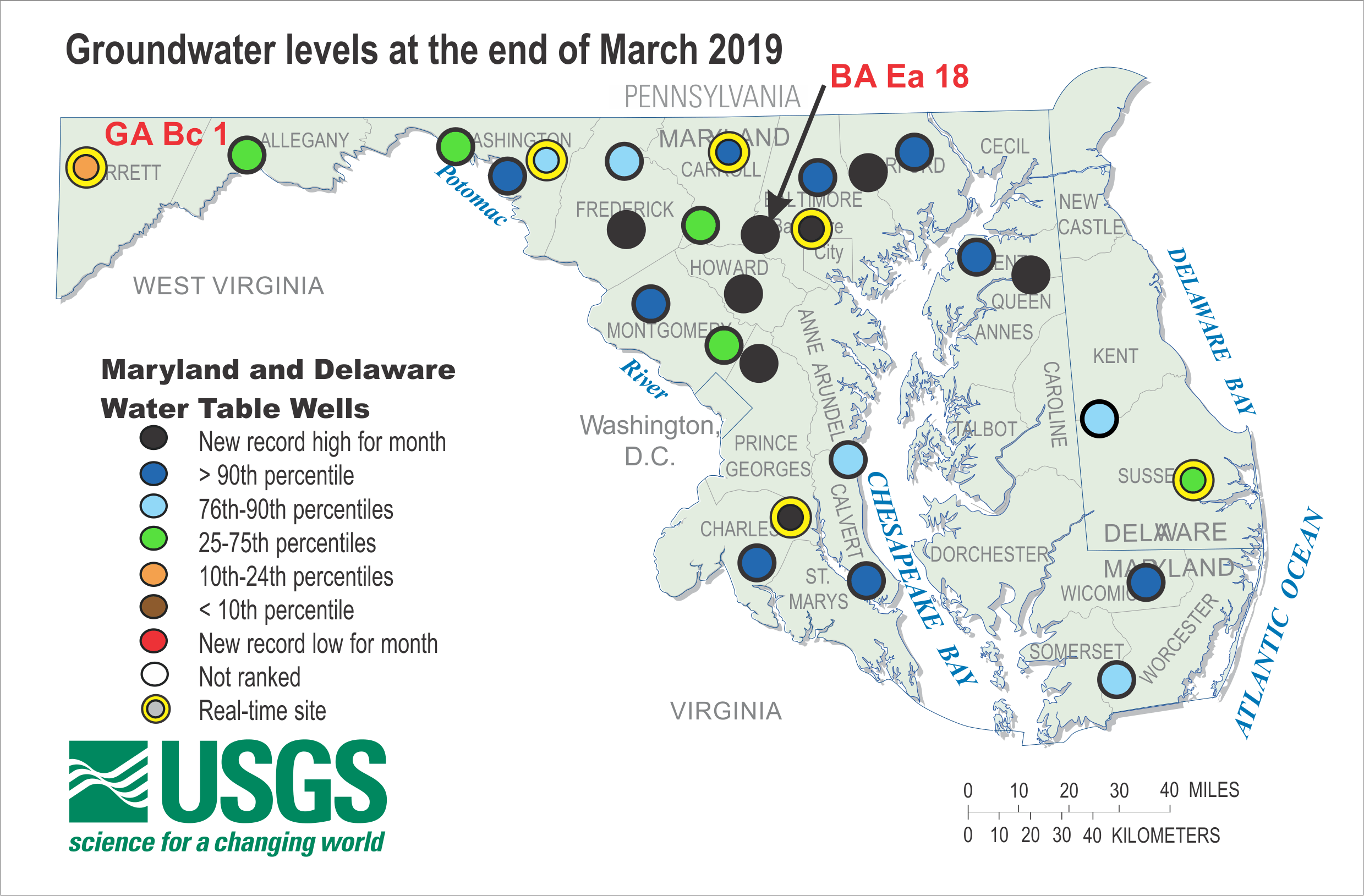
Record highs and above the 90th percentile stick out.
edit: here's a link to the VA groundwater data.
https://www.usgs.gov/centers/water-dashboard/ground?state=va,wv
Family has a house on the river in Kilmarnock. Water is way high currently. Looks close to 3-4 feet high at least.
Sorry guys the meeting ran late and my phone is being SO slow, so updates will be slow, but basically Shenandoah valley is about to get POUNDED if this forecast holds up. It could easily still shift east, if it moves a bit quicker itll hook into central VA droppin a lot of water. Be wary guys.
Word on the street is VA is considering issuing an evacuation in certain regions, and the same for NC. If you're on a first floor apartment stock up on the essentials and be ready. Stay safe guys and sorry I cant get this out sooner I have a class at 1:00 and have to TA at 2:00 update will come out immediately after that I promise
My wife is heading to Blacksburg for Engineering Expo tomorrow. Should she leave Wednesday evening or Thursday morning to go back to Virginia Beach?
If the Gov orders an evac, will she be able to get back ir wll the roads only allow outbound traffic?
Are they considering evacuating VA Beach area or more of the valley?
The European model has 11.5 inches of rain in Blacksburg.
That can't possibly read 38.1 inches in one NC county can it? Or 39.8?
Harvey stalled out around Houston last year and dropped 40+ inches. Florence is going to stall out too. I don't know the likelihood but it is possible. The bad part of this the storm will be pushing air up the mountains so that will wring out more rain so yeah, this could be a really deadly storm.
EDIT: Look at the upper right corner of the image. The max value on that image is 47.9 inches of rain over the time period. That is 4 FEET of rain.
(You read this in Morgan Freeman's voice, didn't you?)
That's my county (Iredell, north of Charlotte). We have tix for this weekend's game, and I'm having a hard time imagining this game happening.
Where bouts? My family's from Statesville. Got messed up pretty good during Hugo a few years (decades) back.
I'm in Mooresville, south end of the county. Thankfully the models from this morning look a little better, *only* 6" of rain for us
Anywhere near Lake Norman? My wife's parents have a house there we venture to. I wouldn't mind finding Hokies in/around the area if I'm in town around Thanksgiving looking to watch LOLUVA get trounced.
I can see the lake from my house. As my wife says, we're lake-adjacent, not lakefront.
I'll be at the UVA game, but I'm happy to recommend a few good spots to watch the game in Mooresville. Bad Daddy's Burger Bar and Kickback Jack's have good beer, tons of TVs and decent food.
So my wife is a big equestrian fan, and noted that the World Equestrian Games (essentially, the Olympics) are in Tryon, NC starting today and going for two weeks.
Hope they brought snorkels and flippers for the horses.
Good God
Absolute unit
Used that to create this:
Florence... the Machine
So either ECU is coming up early or the game is about to be canceled.
I think the game gets postponed before it gets canceled.
No way.
It'd have to be water polo. This game isn't happening.
Sounds like recon data found category 5 winds. This thing is serious.
Maybe I should have waited until she was closer to the coast, but what the heck. I can always redo it.
This one is for you older Hokie fans.
Did Mel piss her off
I think so. It appears Mel is somewhere in the Carolinas or Virginia.
🚨 VB residents 🚨
Potential for evacuations, not mandatory yet
The NA model has it hitting closer to VB and still talking about stalling near the coast.
The Euro has it on train tracks inland towards Asheville, then stalling in the hills.
Damn.... This thing looks like a monster.... Thinking about all you guys. If anyone is traveling as far as SW Florida or even Tampa area, let me know.
Looks like the Euro model projects worse rains for Charlotte than the Triangle but still damn this thing gonna tear up NC and VA
#NC2VA
Drove by Walmart in Raleigh this afternoon and you would think the world was ending. Stay safe everyone!
I have to get gas here in Raleigh later. Please say a prayer for me.
I couldn't find any water in Raleigh today. Filled up the car yesterday, and I'm not terribly concerned about the water situation, but I'd rather be prepared that not.
The sink will still work even if a hurricane comes.
Yes, because of a little thing called gravity.
Water does not arrive at your tap in that manner...
Additionally significant flooding can cause contamination in tap water sources, can be a dicey situation.
Contamination is my primary concern. However, I have a gas stove, so if there is a boil water advisory, I have no problem doing that. I also have a handy filter I use to filter water sources when camping, so I have options.
So, you're saying you're not going to have to resort to urine purification using a solar still? Good to hear.
I still gotta cut my grass..from what it sounds like...if I dont, I will need a machete to get to my mailbox...lol
The lawn service one of my friends uses is still planning to aerate and seed her yard tomorrow. Told her that historically, when they do this right before a big storm, yards turn out fantastic. I'm skeptical, but they will re-seed if the seed washes away, so I guess we wait and see.
That's what I'm about to do tomorrow after work.
If you believe in the Euro model, we're only supposed to get about 5-6 inches of rain in Raleigh for the next 10 days. Even the NOAA model is showing our totals around 7 inches over that same time. Of course this all could change, but a very different picture than the 15-20 inches we were talking about yesterday.
I love that I've trusted what I've read here far more than any other forecast. Thanks eshiben5 for keeping us all informed without being too apocalyptic or too technical.
I love that the Euro model isn't shunned in here...and it typically is better.
I know. After reading these threads, I see weather forecasters referencing the GFS model, and I think to myself...
At least the new V3 version of the GFS seems to have fixed some of the really bad issues. Unfortunately that won't be active until sometime next year.
SC just sent out their evacuation orders:
Charleston, Beaufort, Colleton, Dorechester, and GeorgetownAll counties.https://www.thestate.com/news/state/south-carolina/article218123955.html
It's actually ALL COUNTIES ALL ZONES in SC.
All counties? I know its all zones
Will Update my original comment this seems to be correct:
https://www.thestate.com/news/state/south-carolina/article218123955.html
So all coastal counties or surrounding that have evacuation zones are being evacuated. Roads into Charleston and Myrtle Beach will be reversed starting tomorrow.
Sauce? My mother was going down there tomorrow to get my grandmother
In my original comment. All coastal counties have a mandatory evac.
South Carolina Emergency Management
Leave now to go do it.
She needs to leave now and get her.
We left Hilton Head before 5 this morning. Didn't want to get stuck in outbound traffic (it worked; we didn't). By the time we made it back to Upstate SC and were picking up the dogs from the kennel, they had lifted the evacuation order for HH. Yep, that actually happened.
So glad my parents didn't leave this morning to come stay with me in Cola...they would have been pissed to get here at noon when they lifted the evac.
We were . . . less than happy, but now that we're here, we'll make the most of it. And at least our dogs are deliriously ecstatic.
How do your parents like living there? My adult stepson was with us this week for our short vacation, and he's seriously thinking about moving to HHI. He telecommutes, and can work from pretty much anywhere. My husband and I, of course, think this is a fabulous idea. But he's wondering if he would get tired of it, especially being a younger person.
My parents love it. As someone in their mid twenties I probably wouldn't consider it unless I was settling down to start a family. There's not much of a young professional crowd there, definitely don't see too many people my age out often. The Tourist season is an absolute nightmare to get around most days (except Saturday). There are plenty of positives though, its far less crowded than Charleston, pace of life is much slower, etc.
To be fair the new Euro model is bad for every single bit of the South Carolina coast but it doesn't make any sense to me.
Yeah, that was pretty ominous. Someone reported here that the mandatory evacuation for HHI was lifted at noon today, and now the latest euro model has Flo tracking down the SC coast. Crazy.
Here's my situation:
I live in Wilmington, NC and had planned to travel to Boone, NC this weekend for a team reunion. We have family in the Greensboro area, and hod also thought about evacuating to there, but these Euro models seem to make it look bad wherever we had planned to go. Am I reading these things right?
Side note: Man, TKPing will make you a smarter person!
Ironically, my advice is so head to florida or Georgia if possible. You'll be fine down there. I'll take words I never thought I'd say during hurricane season for 500 alex
Unconfirmed reports from USCG. She's got Cat 5 wind speeds now
Yikes: that is the first word that comes to mind. This thing is for real my current reaction even in VA beach:
So everyone is throwing around images of the EURO hooking west, and that is still plausible but be prepared for any situation. It could still easily hook east and the euro composite still has all of VA getting as much as 20" of rain all over the region. If you are near Willmington get the fuck out. The system is probably going to pass right over the Raleigh-Durham area and dump rain on Blacksburg. I wouldn't be shocked at all for this game to be cancelled or pushed to another week. All across VA and NC be ready to get 20" of rain. The bullseye hasn't zeroed in yet and could land anywhere but make no mistake this bad boy is making landfall. I'll attach a gif of what I'm looking at tonight, and I really trust the euro composite as it has been zeroed in on this route (give or take a slight adjustment) for the better part of a week. It also rarely lets me down.
Everyone in VA be ready for a ton of rainfall. I cannot stress this enough. If you are near a coast line stock up on water, unplug electronics, move cars to high altitudes etc. BE PREPARED, I wouldn't be shocked if the entire state got over 10" of rain. We've spoken ad nauseum about the fact that the surface is very saturated, hell on my commute to HU this morning there was about a foot of water around ODU in the road. The water has nowhere to go except piling up. Be ready folks
Thanks eshiben. I've been debating where I might ride this thing out here in VA Beach, but thanks to this I have decided there is no circumstance that I am staying at my Zone A home. Too much of a flood risk. Its the price you pay for being close to the beach I guess. Now I just need to decide if I am leaving the area completely or hunkering down in town with family.
I'm on 71st street and starting to worry!
Surprisingly, 71st st is in zone B. You can check it out at the link below by typing in your address. Like i said in my other comment, I'm in Zone A on Shore Dr, so I have been mandated to evacuate. really hoping my 1st floor condo doesn't get rekt by flooding...
https://vdemgis.maps.arcgis.com/apps/webappviewer/index.html?id=5797524b...
This is helpful, thanks!
Just moved to Raleigh. I wanted to use my returned security deposit for a canoe but got talked down because "we needed it for bills." Last time I pay a bill instead of making an impulse buy
I can't imagine its going to be too, too bad here. We haven't been hit with the kind of steady rain other areas have gotten this year. Yes, there will be flooding and places in and around Crabtree are going to be downright unpassable, but I'd say for the most part we should be ok. If also helps that we're on the very far edge of the Neuse RivIer basin (I think Falls Lake effectively begins it). I'd be much more worried about everyone to the east where the Neuse will be flowing to and through. We should largely avoid all the secondary flooding as rainfall starts to flow out downstream.
Based on heavy rain fall in the past in raleigh I would think there would be really bad localized flooding around the lakes/steams. Based on the storms over the last couple of years I would also expect it to be difficult to navigate within the city proper by car due to localized flooding so eveyrone should make sure they are ready to stay in place for a couple of days if nothing else
Yep. If we get the forecasted amount of rain, I'm pretty much stuck in my neighborhood until it recedes.
Dude, you're gonna jinx us. I swear I think you do this on purpose.
That being said, you may be right about everybody east. All the towns downstream from Raleigh all the way out to the coast got the worst of it after Matthew. What was really terrible is they knew it was coming for multiple days after the actual storm and couldn't do a thing to stop it.
And we are supposed to get twice as much rain with this as we got in Matthew. Not good. In Raleigh, I would think the usual flooding areas are going to get it really bad, the whole Crabtree area might be underwater for a week after this, low spots downtown, a few areas near the airport (Evans Rd) and anywhere that has an active stream through it will see water higher than they have ever seen before.
But truth be told I'm far more worried about having power this time next week (we lost power for over a week in '96 after Fran) and having a tree hit the house than I am about flooding. I really don't like some of these models that show winds upwards of 80mph as the eye approaches Raleigh.
What are these models saying about SC? Honestly my parents just got the mandatory evac orders but they're essentially on the GA line (albeit on a island that's very low lying) they're planning on coming up here but if Central SC is getting anything like what Charlotte is projected we're gonna be flooded too.
It depends exactly where they are, they're probably really close to the line. If there was ever a weekend to take a short trip down to Atlanta or inland a little bit I'd recommend it. I would hate to be doom and gloom without knowing the exact location however
They're on Hilton Head Island. Seemingly better outlook rain wise than here in central SC
theyll probably be ok
Thanks that's what I've told them. They're packed and ready to go if things change, the predicted surges for their area will put water close to their house but they should be fine post land fall.
You're scaring me.
My phone is blowing up with alerts in SC right now.
I'm in the Atlantic Beach area and haven't got word yet to evacuate (though much speculation we are going to do mandatory evacuation) thinking of going to Midlothian where some friends live, I don't know if that's fine but they said they might get 12" of rain.
...you should get out and gift me your house :-) /S..... I love Atlantic Beach and hope it fares well
Sorry I live in an apartment in Newport :) (just said near Atlantic Beach to give a reference of where I am located). In all seriousness I am waiting for work to give me an official wording to evacuate or not, I've been planning where I am going either with work friends in Raleigh or Charlotte or college friend in Midlothian.
My sister lives in Newport and she's getting the hell out tomorrow and coming to stay with me until further notice. Good luck.
you play warhammer in newport news and we never exchanged numbers because.....?
Newport, NC (sorry didn't specify). Only lived in Newport News when I was younger when father was in the Coast Guard, but when I did play was my last year at Tech, Midlothian at Battlegrounds just past Westchester Commons when I was home for Summer and Winter, and now at Havelock, NC. Was thinking near Brandermill (stayed at the Holiday Inn there when I went up for an Apocalypse Game) since I have a friend that lives in Brandermill.
Yeah leave atlantic beach. Where in midlothian? be ready to be trapped there and a ton of rainfall
Leaving Newport, NC in the morning on the 12th, got word from work that it's all administrative leave for us for the rest of the week. Decided to go to Asheville, NC, was thinking at Brandermill with a college friend that lives there but saw the rain projection so changed that plan, some of my coworkers are from Asheville with family still there so I am going that way. My parents might get a lot of rain in Cumberland, VA and they are not there because of my father working in Charleston, SC right now and my mom decided to go there with him.
I sure hope he's leaving Charleston...
I think they are last time I talked to them, he works Military Sealift Command so he has to do some stuff there before they leave, will ask them before I leave tomorrow to be sure they will be ok I've been packing and moving a lot of stuff away from the windows in my apartment right after work today haven't had much time to talk to them right now (my mom would kill me if I lose/break the Philly Hunter Pence bobblehead and the Philly Gnome that was my grandmothers).
What about that dam in Lynchburg? Did they get that repaired properly?
This could be an issue. Lynchburg is gonna get slammed pretty friggin hard. Anyone else have expertise with this?
I have a feeling my parents in Danville are going to get slammed. I remember when Fran went through in 96. Loss of power and flooding. They also had major flooding back in the spring. If it hits as bad as they say Riverside Dr is going to be washed out.... I know the river will be well past flood stage.
Hopefully Two Witches bill be OK. I'm surprised Memorial and Riverside don't flood more than they do. That rain earlier this year was no joke for Southside.
Yeah and that was just 6-7". We're over at the speedway helping them get prepped for it. Clay Earles couldn't have picked a more holler of a holler if he tried.
I was birthed in that holler.
Birthed at a NASCAR race. If that's not factual I don't wanna know it.
Wasknick was probably birthed in turn 4 on the final lap.
The city drained the lake, made repairs and re-opened Lakeside Drive. The lake remains drained, so it shouldn't be a concern. Plenty of others in the area to be concerned about though.
would you recommend getting out of the NRV, eshiben?
depending on where you live absolutely. flooding will absolutely be a problem here, if you're in a low point expect it to fill up really quick
How would one determine a low point? I've looked at flood maps and topography- is there anything better out there for Blacksburg?
I would recommend that you look at FEMA's mapped floodplain areas on their website. Anywhere in or near the 100-year floodplain line will probably get slammed. This is not an all inclusive resource as many areas outside of mapped floodplains will flood, but it is a good starting point.
Edit: I will also add that if your house is in a FEMA floodplain, you probably already have flood insurance.
Thanks again- we are on the north side of Blacksburg, and in a zone x flood risk area. Only problem is where my house sits and the runoff from the street directs right to my window wells. Bought a bunch of extra sandbags and a utility pump, but with this much water not sure it will help!
If you don't have a generator to run said pump, you should consider getting one.
What about Staunton, Waynesboro? Is DC a viable place to go to ride it out?
DC should be out of range of the storm, you ought to be safe there
Thanks for all of your info, Eshiben. Does DC have anything to worry about? Haven't been able to find rainfall totals for us. Thanks!
I have seen rainfalls looking to be 16-20" if the hurricane follows the GFS model and stalls over Virginia Beach, but I think the consensus is that the Euro model is more likely which should curb the rainfall a bit.
So DC is a tricky one, I think you all will spared for the most part, outflow could still easily drop an inch of rain on you. However if the hurricane creeps further north your precipitation amounts increase exponentially. I think you'll be ok up there
https://hazards-fema.maps.arcgis.com/apps/webappviewer/index.html?id=8b0...
The FEMA link above is a nice starting point for folks to look at with flooding. It's painfully slow, but you should be able to click to open a legend, and move to whatever geographical point of interest.
Thank you for linking this! Was about to edit my post with the link.
Also, on the FEMA website you can click on an area and download the FIRM panel as a PDF.
I know you're getting bombarded with questions. This isn't our first rodeo, but new location. Chesapeake (great Bridge & Battlefield area); our usual "head for the hills" location is Shenandoah County. Do we stay or do we go?
ShenCo resident here: it's been raining all weekend on already saturated ground. Got 2 inches of rain yesterday and all the creeks are running basically at the top of the banks right now, with forecasts showing more rain all week. I know nothing of weather forecasting, but everything I've seen has me pretty puckered right now. No real choice for us other than riding out the storm, but I'm awaiting the forecasts for later this week to see how worried I should be.
I'm on the other side of the mountain in Madison County and the creeks are the same here. I'm beginning to get a little concerned myself. I honestly have no idea how the grounds and rivers can hold more rain. Ugh....
We're on high ground there, but might basically be trapped. Matter of timing I think.
phew, I'd stay in Chesapeake, Ill update again tomorrow if it keeps shifting east. Keep an eye on it, shenandoah is not a safe zone
I'll be heading to Great Bridge tomorrow morning.
I know we don't post stuff behind paywall's here but this is seems like it should get an exception. The Washington Post just put up an article about how Florence could be like Harvey. This isn't a good sign.
WashPo
I blame Weezer. Remaking a classic made Mother Nature angry.
Yeah. I'm not fond of the Weezer cover...
Toto is not amused
This one's not bad. Toto might be amused.
Stay for the outtro. It's worth the wait.
That's hilarious.
This is pretty awesome
No Africa by Toto subthread is complete without...
Had never seen that before, very amusing.
Hampton Roads Zone A being evacuated and of course VA's zone lookup tool is down. Here's a GIS tool to help you figure it out if you aren't sure.
I'm in Zone D. I really don't think it'll be bad in Hampton Roads. A lot of rain, but nothing like further west in the state.
https://www.tropicaltidbits.com/storminfo/06L_tracks_18z.png
I don't know man. Things are looking like it could get real bad on the south side.
Lived in Chesapeake most of my life. This is the first mandatory evacuation I can remember.
Be safe.
What parts of Chesapeake are being evacuated? My parents, according to the link above, are in Zone C....that's where we plan to evacuate to....
Just zone A so far as I am aware.
Edit: My and my wife are headed west to stay with the in-laws. My parents are sheltering /assisting others sheltering at their church in Zone C.
Thanks. I grew up in Great Bridge, I never knew there were evacuation zones until today, lol. I also don't ever remember having an evacuation in Chesapeake.
Paging Eshiben.... Comments on the 5 pm forecast discussion? Sounds like the track is shifted east but not as far east as the model consensus if I'm reading that right.
Yeah as i mentioned earlier (I think?) I had a hunch it was shifting east. I think we get like 8ish inches (zing)
Based off of what I saw in Richmond this afternoon alone.....
Everyone rememeber, you will have water. You potentially could have to boil it, but its gonna be there. Well pumps may not run but you can find water.
That being said. Everyone has water now, right? If you are worried about it, start pulling out every chalice you have in your house and fill it with damn water. Everyone has something to put water in. Fill your damn bathtub if it looks like it's gonna be bad. Don't waste the resources you have currently. I couldn't believe the number of people at check out lines this evening buying as much water as they can carry.
I'm actually filling my freezer with bags of water. It will help keep my stuff cold longer, and then I have drinking water if needed.
ANDDDDD IT CAN GO INTO COOLERS IF NECESSARY!! AND AFTER IT MELTS CAN BE DRUNKEN!!
My diploma from Tech doesn't say engineer, but I excel at redneck engineering courtesy of good ol' Amelia county.
dont drink water u freeze in a bottle the plastic mixes into it and its not good, im a water treatment operator so just giving u a heads up.
I'm fairly certain I'll still have tap water, even if we lose power. And my water heater is gas, so I'll probably even have hot water. I'm more concerned about contamination cause by flooding, but I have the means to boil water and I have a filter. More than likely my frozen baggies will be used for icing down coolers and watering the plants after everything is said and done.
See, I typically buy a bunch of spring water before a storm...but, whatever I don't use during/post storm, I use for beer brewing (I buy spring water for brewing). So, it's a win-win for me
Having some bottled water is one thing. It is also a good idea. But these people buying 10 or more cases are just being ridiculous and keeping it from people who may actually need it.
And like I said. The water from the tap is fine now. Store it.
So just saw a video of dozens if not more ambulances evacuating the hospitals in Murrells Inlet and Georgetown SC. They have not done this before. I would post but it's on Facebook I'm not sure how to copy it or post it here.
It's a good call. They waited too long to do that with Irma down here last year. The hospital my fiance works at was in complete disarray for almost a week after. I went to visit her there the night after it passed and one of the elevators was sparking, there was no running water, and they were already running low on food. It's honestly a miracle some people in there lived through it. Getting people out of hospitals early is always the best call IMO
euro composite run. Keep an eye if it shifts a little bit east it could cause some more issues towards VA beach. Be ready for some heavy winds and severe storms in the tidewater region, the further west you go the more rainfall you're looking at
I feel like this deserves some mentioning. I currently live in flood zone A in norfolk, I am planning on relocating to a less flood prone area in chesapeake with my in-laws. However I will let you guys know if my plans change. I think you'll be ok in that region, be weary of some severe storm outbreaks though
Zone A here, too. Just got the call from the sheriff. No intention of leaving at this point.
Zone A in Chesapeake. My neighborhood streets flooded pretty bad over the weekend so we are headed to stay with the inlaws for a few days out in Troutville.
I've lived in Chesapeake most of my life. I have never received a mandatory evacuation order before. I hope it's just an abundance of caution.
Stay safe out there.
I grew up in Great Bridge area, on Butts Station Road. Also lived further out on Gallbush Road. We never got a mandatory evac notice either. Lived in Norfolk as a child and went through the eyes of two hurricanes, but no evacuation then either. Of course, that was in the '50s, things were different then. I mainly remember one time that a trash can from up the street blew down the street for a long ways. We all thought it was funny. After the eye passed, we got the treat of seeing it blow all the way back up the street toward where it came from.
I'm not sure Troutville is the better option, though. Looks like inland rainfall may be much worse than coastal, and Troutville isn't a flat sandy soak it all up with no problem sorta place. Be safe yourself and best of luck to all.
I'm in the Hickory area of Chesapeake. Zone D. I think I should be ok here.
Thanks for the info, im in zone C
Where does the model have landfall at? Trying to see if the wall and worst winds will extend down to Murrells Inlet SC.
looks like bald head island
The good news is that very, very few people live on that island full time. The bad news is that those who do might be screwed as that is a resort island where the only way on or off is via ferry.
and yes they will
Yep pretty anything from wilmington South looks like the wall will go over them.
What's this timeframe? And what might things look like by Saturday/Sunday?
Depends where you're talking about
Portsmouth/Chesapeake
by the end of sunday the bad part will be done, peak storm will be Friday night saturday I believe
So this shits on Virginia pretty good. Eye over Greensboro, Danville, Blacksburg kind of path...
I live in Charlotte. Luckily I live on the second floor of a very strong building. I reckon I'll just be sitting on my porch watching the the roads go all 2016 UNC once it starts.
Just got a text from UNC. Classes are all cancelled after 5PM tomorrow (Tuesday) and for the rest of the week.
How does one cancel a fake class?
Saw that one coming as soon as I posted. lol
I'd joke right along with you, but then I'd feel some kind of way about it...
NC State did the same, for anyone wondering
First time commenter here.
Planning on driving from the Winston-Salem, NC area to Blacksburg on Friday....good idea or bad? I figure I'm heading uphill, so it can't be that bad. Right?
This is going to be really bad. They are going to be measuring rain in feet in areas with this one. There is likely to be flooding and downed trees everywhere. It is likely going to be very dangerous to drive in Virginia and North Carolina this weekend based on this current track. You are going to have to watch conditions closer to your travel time and have alternate plans ready if required.
You would probably be much better served driving in a SouthWesterly direction...I think you're trading bad for equally bad.
On that note, any Hokies trying to get the hell away from this thing that would like a place to crash in Central Florida are welcome here.
From someone who flirted with heading North from Irma a year ago, gas and hotel rooms are extremely hard to come by. Doing a quick Booking.com search, I'm surprised there is as much available in GA is is there seems to be for late this week.
Head to Georgia. Spend a weekend in Atlanta or something. Winston Salem won't be good, and Blacksburg will be the same.
Is Williamsburg pretty much in the same boat as the rest of Hampton Roads? We're not in any zones here, other than Jamestowne Island, but I can assume heavy rain and strong winds, right?
Yeah couple inches of rain, some severe weather outbreaks. Looking over the models one last time before bed
Kevin Myatt has a seemingly more conservative article out now. 3+" of rain for SWVA, with a comment about keeping that upper limit open ended. Thoughts on this prediction?
Kevin Myatt RT Latest Florence Predictions
Is there a website where you go to look at the model outputs? I would love to nerd out and look at some of the details beyond just the NHC static cone images.
Go to Windy.com and have some fun
Love that site. I wish I could have it set as a dynamic desktop background, but then I would never get any work done.
Welp, there goes any hope of being productive today. That website is awesome. How have I never heard of this before?
Thanks!
I just tuned out and spent like five minutes staring the wind arrows. It's kind of mesmerizing.
www.tropicaltidbits.com
The Euro has changed considerably from last night. It's now stalling out over Wilmington for a few days and then moving west.
Just saw this and was wondering if this could change things for those of us in virginia and in SWVA since it doesnt have the eye going inland now.
If this new path holds, the coast is gonna get wrecked, but Virginia may be spared a lot of rain.
Noticed that too this morning. Blacksburg went from a predicted ~5in of rain accum. over the next 5 days to 1-2in. Quite a shift, no?
Maybe we're not all severely screwed?
8 AM Update from the NWS
Anyone got a screenshot FB is blocked here.
I guess this means that the stall over western VA isn't happening?
IF this holds accurate Richmond city proper going to be a very bad place to be unless you are on one of the hills.
This appears to be based on the GFS. The Euro is now showing a hard turn to the left once Flo comes on shore which would be worse for S. Carolina, better for Virginia.
Yeah the Euro destroys NC. It actually just sits right on shore from landfall Thursday to early Saturday before heading west south west.
Sounds like the Euro model has been watching a few too many clips of Bud Foster's D playing NC teams...
Where's' this from? I can't find a model that has Richmond getting more than 5 inches in the worst case over the next 10 days
Shit I thought the new model was good news but being in Ashland this update is bad news we just went from 5 inches to 14 hoooo wee time get the canoes out cause my work wont give a damn
I am right here with you buddy
That makes 3 of us... I work at a dual fuel combined cycle power station.
So I'm still not totally sold on the new landfall zone put out by the NWS however I'm not totally shocked that its sitting there rotating in space. The euro is basically stating that the storm isnt going to arrive quite as soon and will get lodged somewhere near the coast and drop a lot of water. much better news for shenandoah VA and most of VA. however outflow will still probably pound the 757 area. I'm not completely convinced by this latest model run. Will wait until later tonight to really stick to my guns. If this storm arrives a little sooner it could drop a lot of rain somewhere else, IE central NC or shenandoah VA. A lot of timing going on here. Sticking to my original guns here though with the NC coast. Definitely evacuate if you haven't already this thing will make landfall and do some serious damage to that region, I'd bet money on it.
As a student, should we be less worried about flooding around campus areas now? Or will it still be no bueno?
according to this much less, buuuuut I'm not completely sold. Give it some time
10-4. Thank you for all this information you are willing to give everyone!
The last eruo I looked at looks terrifying. It looks like it just creams SE NC and then sits there for a while before running through the Carolina's. Whats causing that straight west (sw) push as the storm dies out in the euro?
Where do you go to see the model outputs? When I google things all I get is news outlets churning out their take on it. Would rather just get stuff straight from the horse's (on a treadmill) mouth as well as follow along with the discussion here. I see someone linked "windy.com" earlier but I'm not seeing a method for switching between prediction models there. Sorry if this is a noob question.
Go to Windy.com the bottom right has GFS, NAM, and ECMWF. Then you can drag the time line across the bottom to follow the track....warning this website can entertain you for hours if you like looking at cool colors and moving dots.
Thanks!
You weren't lying, can't....look....away
It's great. You can also switch to view accumulated rain totals for the next 3, 5, or 10 days.
Playing around with that website now.. As bad as Florence is going to be, just be glad we aren't along the south side of Australia right now. That looks absurd.
I seen that too. What the hell is going on down there
What's going on down there is called "Mercator Projection". Everything looks bigger, and worse, that way.
I didn't feel like working today and the European now has it coming straight over my location dumping some rain, so I showed my entire office, now no one is getting anything done.
Can't fire me for doing nothing if everyone is doing nothing.
The north Atlantic looks like a nasty place to be mid-next week......
tropicaltidbits.com is a great site. Click on models on top of page.
gonna look into that after class, currently running a tad late, expect an update over lunch
WVU @ NCSU Canceled, FWIW
https://www.wowktv.com/news/west-virginia/sources-saturday-s-wvu-nc-stat...
Edit: This report is being called into question.
Edit II: This report is highly suspect.
Edit III: This report is no longer in question or highly suspect
That report is being called into question.
This report is highly suspect.
(Waiting to see if LawdHamGreasy will edit this into his post as well.)
Did you see the ND vs. NCSU game two years ago on the day we played UNC. Their field was a freaking disaster compared to UNC's.
It also looked like a blast. Not that I wasn't having fun at Kenan down the road.
That game at Lane Stadium South was a blast. Tailgated in one of the parking garages and we put such a smackdown on the fighting class-dodgers that I didn't even care how hard it was raining during the game.
Raleigh also got hit a good bit harder than Chapel Hill did, I was shocked at the difference in damage and flooding driving home on 40/440 just going the small distance
And it was raining harder at noon than late afternoon that day.
In all honesty, I thought it rained appreciably harder for the 2nd half of the Duke game last year than the UNC hurricane game.
https://www.youtube.com/watch?v=dcZufebr-mU&feature=youtu.be
Interesting stuff from WXRisk. He's in agreement with the Euro Model.
You beat me to it! Interesting video everyone, check it out.
Unc and N.C. state games not happening this weekend.
Wake bc moved up 2 hrs
Sounds like a win win for UNC and State. Allows students and attendees to stay safe and prevent both teams from suffering another embarrassing loss.
Every time I see new posts in this thread, I get excited, thinking that eshiben might have an update. And then I open the thread and am like...
via GIPHY
Who needs Eshiben? I got yall
Question for the WeatherDude when he has a chance...
Does this have any bearing on forecasting (guessing) what this thing may do?
Also,
the latest that we've heard here is that this thing is slowing down. Does that mean that it's running low on fuel, getting revved up, or nothing at all? If it stalls off the coast as the Euro is indicating, is there a possibility of a dumping of a shit ton of rain off the coast and sparing us land dwellers some serious precip?
If these are dumb questions, just let us here in the NC triad know if we're going to make it with latest developments.
Not a weather dude, but the reason that Flo isn't likely to head northeast like that is the high pressure ridge sitting right there keeping it low. If that ridge moves further west bc of the trough in the northwest, then Flo will likely be held to a westward track once it makes landfall.
NC triad looks to be in trouble, but an updated European model comes out at 2pm EDT so let's see what it looks like...
Yeah, the historic paths are nice to have, and make a cool picture, but there are a lot of outside factors at play with each and every one of them. Flo needs to be looked at individually with current conditions.
Did you draw that in Paint? ;^)
I have mad Paint skillz. You don't want to go there.
NC State just canceled classes as of noon tomorrow (was 5pm)
Latest Euro has is pushing even further south. May miss VA entirely. Rainfall along the coast of NC and SC looks brutal though.
Holy shit, 3 feet of rain in the Wilmington area?
OK so I'm heading to the in-laws tomorrow so at some point in the next 24 hours expect a thread #2 to pop up as I wont have a computer anymore and this thing is a bitch to load
So the most recent euro composite has it hovering in NC. As mentioned above this is because its slowing down. Basically its racing into position and the high pressure system to the north will lock it into place, we have a good idea of when the high will get there but therest still a ton of factors that can influence when and where the hurricane will be once that ridge gears up.
SO the most recent Euro run has a much more lax outlook for virginia, but this can vary on a dime. The margins for error here are tiny, for instance: as of now VA beach is looking at ~3" of rain, should the storm take a northward turn of ~50 miles we're looking more at close to 8". This far out 50 miles is next to nothing. That is why you still see a lot of places calling for tons of rain in the regions. I'm still not totally sold on the latest run and am waiting for the next run (this evening). I'm also not completely sold on the southwest turn the model has it making into SC before loopty looping back into NC. I think its much more likely that it still gets locked into the central carolina region. I still think 757 region is looking at a significant amount of rain fall and central va is too. I probably pulled the trigger a tad early on rainfall #s but this last model run has given me a lot more to think about fersure. I reiterate if you're on the NC coast get the flippidy fudge out. I'm not buying that landfall from the NWS and have it still sticking around its original location.
If the storm does indeed slow down the coasts will get hit even harder as it sits offshore and just spins and whips the NC coast into oblivion.
Stay safe out there yall
So do you don't see SC because that H being further north?
So that's what's keeping it from pushing north, the euro thinks its picking up some umph and pushing west if I'm reading this correctly. There are no steering winds or anything to suggest a southwestern movement which is why I'm puzzled and think we should hold off.
That is what is so puzzling to me, there is no meteorological reason for the shift south.
What's your prediction at this point for Greensboro?
So at this point the effects look watered down significantly but I'm not totally sold on it. You're looking at like 4-5" but that can quickly climb to like a foot
The margins for error are tiny with hurricanes. The cutoff is really small for actually facing the storm and the outflow. As I mentioned before 50 miles can be the difference between 3" and a foot which is...a shit ton of rain. For reference Isabelle dropped about 6" of rain in the va beach/Chesapeake area
Its crazy, here in Raleigh, it looks like we're on the border of comparatively no rain at around 2" and a complete deluge with about 8-12", depending on how fast it wants to push up.
I'm still just stunned they're calling for 37"+ of rain in the Wilmington area. I'm not sure I've ever seen a prediction like that before. Thankfully, they're already on the intercoastal, so hopefully it'll help disperse any flooding quickly, but man... that's mind boggling.
There was over 50" in spots from Hurricane Harvey in Texas last year.
That's insane. I literally can't picture seeing it rain that hard for that long.
The actual coastal areas there are going to be in a lot of hurt they'll take that rain and a beating of days of 10-20ft waves + the wind. This look horrendous for Wilmington, Top Sail, and the surrounding coast.
37 inches is a year's worth of rain, right?
There about...yes.
100% chance of Stamey's Barbeque!
Of course it does depend on your location when it hits. In my case I'm right across the street today working at the bug repellant plant.
Gonna be pretty annoying if we cancel a game and end up only getting an inch or two of rain. Even Greenville is only slated for ~6 over five days now. Maybe I'm being naive, but that doesn't seem like something to stop the world over (I'm probably just uneducated on this, and salty about losing a pizza and pitcher at the Cellar), although I'm glad I'm not in Wilmington.
This is why Whit & Co are holding off on any announcements until tomorrow. Closer to land fall = better forecasts
It's not just that it's going to rain 6 in or so in Greenville over 5 days, it's that there's also going to be a storm surge because Greenville is right on the Tar Pamlico basin and all of the upstream water will be coming back downstream eventually
6" of rain is a shit ton. For reference that's what isabelle dropped on the va beach region.
Also the potential for this to turn into an foot or 20" exists sooooo as long as that exists you have to respect it because you cant have the system blow in and have the game played.
This guy has the most accurate forecast of what's about to happen to the coast...
Wow.... that's just... no words....
This clearly must go ANTI-arnie.
As someone who just looks at this with a blank stare, what can I expect in Charlotte?
Rain, lots of rain
A load of rain.
With the outcry over on The Sabre of their game is being moved to Nashville, you would think the forecast is partly cloudy with a 10% chance of rain
I don't know why they cryin'. They need every W they can get, and they don't give 'em out for cancelled games.
Remind me why would anyone would ever complain about an excuse to go to Nashville?
The newest Euro model is call "Fuck you Wilmington and South Carolina"
Yeah that model run has it just posting up off the coast while drifting south. Will be crazy if it follows that path. Huge difference from just 24 hours ago, let's wait another 24 for the changes that come.
I woke up this morning expecting that model to be in the trash and now GFS coppied it
As of the 8 AM run, now the Euro models are the most extreme southern paths.
I have a feeling this will be the storm that shows the biggest weaknesses in the Euro model.
I don't have the confidence that the high pressure ridge is going to be strong enough for the storm to get deflected by 90 degrees.
Any update on what its gonna be like in chesapeake great bridge area?
We're not in an evac zone as long as you aren't right next to the canal. TS warning has been issued.
The sunset with the funny cloud formations is gorgeous right now. I fully succumb to the calm before the storm.
Yeah im in zone C so im kinda just doing outdoor prep and hunkering down
Yeah but nothing in Chesapeake is very high. Isn't the highest part of Chesapeake at 18ft above sea level?
That rain isn't going to run anywhere fast.
Eshiben, the NHC forecast has Flo dropping about 25 mph of wind around 10-12 hours before official landfall. I'm guessing that's due to the interaction with land of the western portion of the storm?
I mean anything over 110mph is still cause for concern, but that seems like a fairly significant dump. I'm uneducated in the field though
Lol, was watching the Weather Channel and a segment about tracking the storm/the catastrophic rain and wind forecast, then immediately cuts to a commercial set to the Scorpions Rock You Like A Hurricane.
Updated rainfall projections:
757 getting as much rain as Raleigh.
Athens GA getting MORE rain than Raleigh.
Think I'll stay put.
We're focusing on Wilmington and the coast... but poor Lumberton, NC. I think they're still rebuilding after Matthew, and now this.
https://twitter.com/thestormandsky/status/1039667475900772352?s=20
Dunno how to embed tweets buuuuut
Came for serious weather update left with Benny hill theme stuck in my head for the next few days, well played
I gotchu eshiben. But was it mean to us weather illiterate folks? Just that the GFS model is hot garbage
Eshiben5: Will Florence make landfall in Wilmington, Charleston, or Savannah?
18z GFS: Yes.
Just wait till the 24z edition (or is it 00z?). You won't believe what it does next!
Weather by BuzzFeed
Waiting on the 11 o clock release but the 8pm one shows more impact on central valley than I thought it would https://www.nhc.noaa.gov/refresh/graphics_at1+shtml/212435.shtml?rainqpf...
South ATL checking in. Looks like I'm gonna have to get ready for a nasty wave of storms
I'm glad we no longer live in Myrtle Beach area. With this new southern track change it's going to rough. A lot of people there though are not leaving.
Was hoping I would be fine in Savannah, looks like things may get wetter than originally thought
So I think I'm thinking I may have figured out what the models are grabbing here. Upper level winds from that high pressure system parked over Maine (that interestingly dips a little south) are pushing the system south/southwest ever so slightly before it gets grabbed up by a trough coming across early next week and pushed back northeast.
VA and Shenandoah valley: You're not totally out of this yet. This forecast is looking so much better we may have lucked out at South carolina/GAs expense. I really feel for the NC coast and hope everyone has evacuated at this point. The coast is going to get crushed even if the system doesn't make landfall. It will drop a ton of rain and storm surge will be really destructive. Theres no Florida everglades to protect us this time (see Miami last year). Chesapeake/VA beach all you'll really see out of this is some outflow and a few inches of precipitation and maybe some heavy winds. Expect some thunderstorms Friday/Saturday. As the storm mosies its way down south, cities like Charleston will almost certainly see a ton of rainfall and strong hurricane force winds. We'd almost be better off having it make landfall and then work down the coast, by staying offshore its not weakening as much and still staying organized for longer. Eventually the system will cut through SC and into northern GA and deteriorate dropping a lot of rainfall in that region as well. At this point the next trough will be coming across the mid atlantic, and as we've seen numerous times, the hurricane will follow this pattern and be picked up by it. The tropical depression (still a ton of rain being dropped by it) will kind of mingle with this and start heading northeast back towards the Shenandoah valley and central VA. While I think the euro is being a tad overzealous expect some pretty significant rainfall in the middle of next week as the system makes its last hurrah.
Definitely keep an eye on this system still. As you've seen a ton can change in ~48 hours. But I'm feeling better and better about the euro's forecast.
Stay safe out there hokies
eshiben, would you then say that with the current model, Blacksburg and SWVA as a whole isn't looking at significant rainfall starting until at least Sunday?
Parents just said F it and called me this morning on their way up to Columbia. Their house sits about 10ft above sea level and they figured with the question marks might as well get out of HHI. Looks like Columbia can expect a butt load of rain regardless of how far the storm drops down the coast.
Son just called. He is bailing on Columbia. Not sure Greensboro will be better, but it feels better being together.
thanks for the update, any change for the Raleigh area?
you da man eshiben
So what you're saying is ECU should've waited until Wednesday to make the call for Saturday's game. :)
Based on your experience, do you think that the high 800 miles away from the projected landfall location is going to significantly trap it and push it 90 deg southwest like the Euro is projecting?
Yes, PGFs (IE pressure gradient forces) are big for forcing winds and directions of systems. I'm climbing more and more on board the euro track after what I thought was an odd forecast yesterday. whether it loops back into the shenandoah valley remains to be seen but I think it will make landfall (or damn near close to it) near Willmington before heading due southwest
/eshiben makes storm updates with immense detail for many impact areas
/TKP users all reply asking about what is going to happen where they live
The ONLY trauma center for the Grand Strand / Myrtle Beach just closed including the ER.
If this isn't a damn hint to the people on TWC last night that were staying to ride it out idk what is. I had a friend send a screenshot of a conversation with a person that lives on Top Sail saying they still weren't sure if they were going to evacuate.....I do not understand.
That's where I had my appendix taken out while on vacay (which I absolutely DO NOT recommend for anyone).
It looks like the turn of the storm will be bad news bears for the other Greenville, SC Hokies and myself. We are seeing lots of projections of getting a foot of rain.
well, i evacuated (per the order) and made it safely to Troutville (thriving metropolis) and the storm appears to be avoiding Hampton Roads more than a professional sports franchise.I understand the abundance of caution, but I wish the city/state would have held off a day for the order. Also, I don't want to minimize the damage potential that could end up other places just because it inconveniences me.Anyone know the process for ending the evacuation? Is there a "return" or "all clear" notification that goes out?
Edit: please ignore my complaints above. Question still stands.
The reason evacuation notices go out so early is we need everyone out AND off the roads when the storm hits. In the past dozens of people have died while trying to evac late while in their cars.
That is an excellent point. Please ignore my complaining.
To add to this, evacuating the most at-risk people at the first sign of trouble allows you to add more people to the evacuation list if the forecast changes for the worst.
Virginia actually handled this really well, even if the storm completely misses them.
Evacuation orders will be lifted and you can get back.
Don't know if this was mentioned already, but the VA Emergency Mgt website is back up & running. Able to view the evac zones now.
Great, now that you don't really need them any more.
Rainfall Predictions:
I know there have been some requests here, so leave a one word reply to this comment that you'd like a guesstimate for rainfall amounts as well as any other information you'd like and ill reply to that
Charlotte
Thursday - Sunday very little, I see you getting hurricane force winds and maybe some rain from the outflow but not much more. You're pretty close to the cutoff however and that number will quickly increase if the storm takes a more westward track than southwestward
Next week - keep an eye on the storm looping back around, you could get a fair amount of precipitation if that happens. (couple inches)
Blacksburg
Greenville
Greenville ^^^^ see charlotte above
Blacksburg - be very concerned about the storm looping back around. Again the track is still a ways out and as you can see a lot can change over a few days but should it follow something similar to the euro's forecast you could absolutely see a ton of rainfall from this thing in round 2. Expect a dreary weekend (some rain but not much) and possibly a TON of rain next week. Stay updated
Richmond VA
Rainy with a 100% chance of EPW drinking Woodford.
I heard a very similar forecast. It included drinks at a bar while I watch College Football all day. Less bourbon though, as that always results in sever weather with me.
Portsmouth/VB: rainfall thursday through sunday
Couple inches, wont be bad. Again expect outflow from the storm keep an eye on it looping back through though. Could also get some reasonably dangerous gusts
If the wedding is on for Sunday, I'll be driving down saturday. thanks
Boone, NC
Same story, outflow. Watch the loopty loop you'll be one of the most hard hit should it follow that path
woah, this even embeds the mouseover?
KingGeorgeVA (since I could only use one word)
Greenville, SC
Raleigh